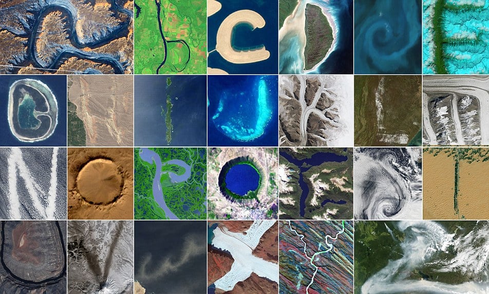
In July 2012, NASA science writer and social media manager Adam P. Voiland enlisted the Internet in an ambitious project: to “help find an alphabet in the sky” based on photographs taken by NASA satellites and astronauts. Now, over three years later, he’s completed his search, and the results are stunningly beautiful.
The “Reading the ABCs from Space” project began when Voiland spotted a V-shaped plume of smoke caused by wildfire burning in the Caribou Mountains in norther Alberta, Canada. That image became the inspiration for the years-long hunt. (Ultimately, it was cut from the final 26 selections, in favor of one taken on March 23 of this year volcanic ash scattered on the snow of Russia’s Kamchatka Peninsula.)
This image was acquired on July 11, 2012, by the Aqua satellite, of wildfire smoke over the Caribou Mountains of northern Alberta, Canada.
Photo: NASA, courtesy Jeff Schmaltz, LANCE MODIS Rapid Response.
“Some letters, like O and C, were easy to find. Others—A, B, and R—were maddeningly difficult,” wrote Voiland on NASA’s Earth Observatory blog of his search. With the help of readers and colleagues, he pored over thousands of images. The earliest photo in the alphabet dates to August 9, 2000, and the most recent was taken August 14, 2015.
The final selections included a wide variety of “ephemeral features like clouds, phytoplankton blooms, and dust clouds,” capturing a full range of earth’s geographic and topographical diversity. Voiland carefully documented the appearance of each letter-like shape, noting the date and time the image was taken, and what part of the earth the photograph captured.
What begins with D? Decomposing detritus and dust deposited on a dimpled island during deglaciation. Deserts, deltas, and deforestation. What else? DATA! Data sets…databases…data systems….data visualizations.
The Enhanced Thematic Mapper on Landsat 7 acquired this image of Akimiski Island in James Bay on August 9, 2000.
Photo: courtesy NASA, caption by Adam Voiland.
“When I finally tracked down all the letters and it was time write captions, I happened to be a new dad and deep into a Dr. Seuss reading phase with my son,” noted Voiland, who has paired the striking satellite imagery with such playful, link-laden commentary as “Bonjour B, what begins with B? Biomass and boreal forests. Beirut, Barcelona, and Brasília. A bunch of babbling birds bunched up along Holla Bend.”
See more images from “Reading the ABCs from Space” below:
What begins with J? Jason-1 and the jet stream. Jerusalem, Jakarta, and Johnson Space Center. This jade-colored coral reef juxtaposed against the jumble of the sea.
On July 17, 2015, the Operational Land Imager on Landsat 8 captured this image of the Trunk Reef near Townsville, Australia.
Photo: courtesy NASA, caption by Adam Voiland.
What begins with M? The meandering Mississippi. MODIS and MISR. Mumbai, Miami, and Moscow. These medial moraines merging muck and minerals for millennia!
On August 14, 2015, the Operational Land Imager (OLI) on Landsat 8 captured this image of glaciers in the Tian Shan mountains in northeastern Kyrgyzstan. The trail of brown sediment in the middle of the uppermost glacier is a medial moraine, a term glaciologists use to describe sediment that accumulates in the middle of merging glaciers.
Photo: courtesy NASA, caption by Adam Voiland.
What begins with S? Swirling stratocumulus sliding over salty Atlantic seas! Stratovolcanoes, sulfates, and sunglint. Satellites and spectrometers.
On April 29, 2009, the Moderate Resolution Imaging Spectroradiometer (MODIS) on the Terra satellite acquired this image of clouds swirling over the Atlantic Ocean.
Photo: courtesy NASA, caption by Adam Voiland.
Big V. Little V. What begins with V? Vast volumes of volcanic ash veering in variable winds! Vladivostok, Venice, and Venezuela’s Lake Valencia.
On March 23, 2015, the Operational Land Imager (OLI) on Landsat 8 acquired this image of ash on the snow around Shiveluch—one of the largest and most active volcanoes on Russia’s Kamchatka Peninsula.
Photo: courtesy NASA, caption by Adam Voiland.
What begin with Y? A youngish underground river yearning for water amidst yellowing yardangs of yesteryear! Yellowstone, the Yukon delta, and the Yellow Sea.
On December 25, 2000, by the Advanced Spaceborne Thermal Emission and Reflection Radiometer (ASTER) on NASA’s Terra satellite captured this false-color image of the Ugab River in Namibia.
Photo: courtesy NASA, caption by Adam Voiland.