

The massive temple complex that is Cambodia’s Angkor Wat is famed as the world’s largest religious monument. Now, researchers have determined the city’s population at its zenith in the 13th century, and the number is impressive: some 700,000 to 900,000 people likely called the Angkor region home, making it one of the world’s largest pre-modern cities. Compare that with the 2019 estimated population for Boston, at 692,600.
The new estimate is based on 30 years of archaeological data from on-the-ground excavations conducted with Cambodia’s APSARA Authority and high-tech scans conducted by airplanes equipped with Light Detection and Ranging (LiDAR) mapping tools, according to a study by the University of British Columbia published last week in the journal Science Advances.
The Khmer Archaeological Lidar Consortium began in 2012, using topographical readings to create three-dimensional maps of the earth’s surface that effectively survey densely vegetated areas that would take years, if not decades, to chart by foot.
Particularly useful in identifying low-lying human-made landscape features easily mistaken for natural formations from eye-level, the technology has already proved transformative in Mexico and Central America. In 2018, archaeologists in Guatemala discovered thousands of unknown Maya structures in one fell swoop thanks to LiDAR.

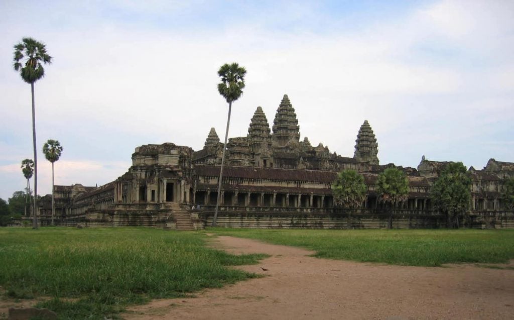
Angkor Wat. Photo by Alison Carter, courtesy of the University of Oregon.
The LiDAR data in Cambodia was similarly illuminating. Though the region’s stone temples seem eternal, not everyone lived in the “downtown” area, around the Angkor Wat and Bayon temples. The homes of many everyday people in the surrounding countryside were considerably more ephemeral, built from organic materials on wooden posts. But while the structures themselves are gone, topographical maps reveal the mounds where the houses once stood, city blocks in a once-thriving urban landscape.
“When you are on the ground in the main parts of the city center it is quite forested,” University of Oregon archaeologist Alison K. Carter, one of the study’s lead authors, said in a statement. “As you walk around you can tell there is something in the landscape around you, but you cannot see anything clearly. LiDAR gave us a beautiful grid of mounds and depressions, which we think were little ponds.”
The research team used inscriptions and changing architectural styles as seen in surviving buildings to help determine when different buildings would have been constructed. Then, they employed machine-learning algorithms to create a model to sort both the different kinds of temples and the LiDAR data to estimate population growth over time, assuming that each household would have been around five people.
What they found was that the population in the metropolitan area around the civic-ceremonial center of Angkor Wat would have grown exponentially as the city, founded in the ninth century, grew.

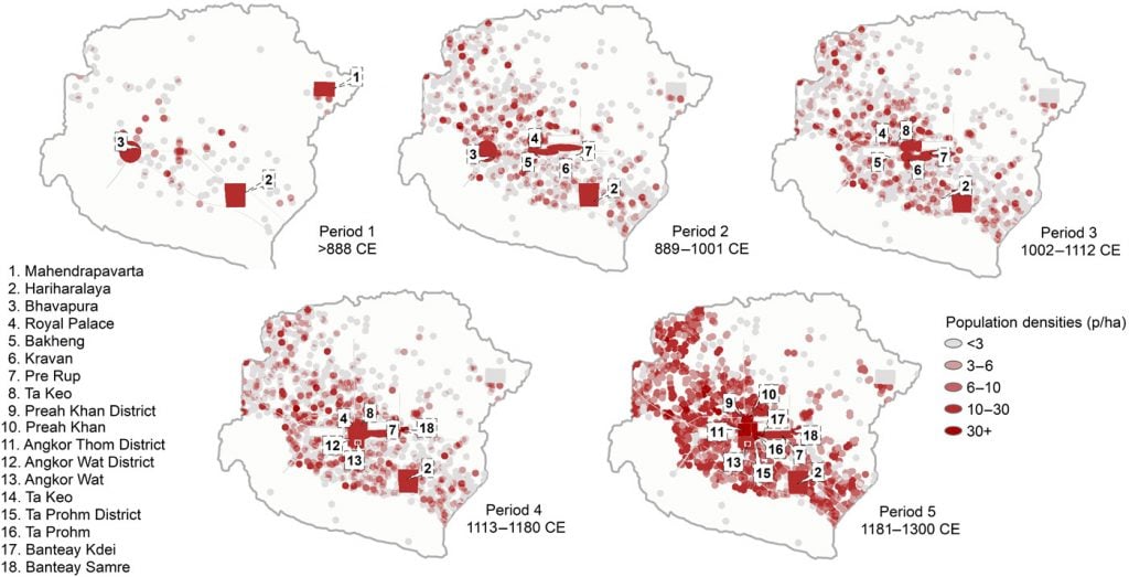
Densities of people per hectare in the Greater Angkor Region over time. Image courtesy of Sarah Klassen, Alison K. Carter, Damian H. Evans, Scott Ortman, Miriam T. Stark, Alyssa A. Loyless, Martin Polkinghorne, Piphal Heng, Michael Hill, Pelle Wijker, Jonathan Niles-Weed, Gary P. Marriner, Christophe Pottier, and Roland J. Fletcher.
If the 900,000 estimate is correct, “this means that the population of Angkor was roughly comparable to the almost 1 million people who lived in ancient Rome at its height,” co-authors Carter and Sarah Klassen, a former postdoctoral researcher at the University of British Columbia, wrote on the Conversation.
The researchers believe their findings could be an important reference point for comparative urbanism studies, particularly with regard to how climate change may have contributed to Angkor Wat’s ultimate decline, and the climate crisis currently facing contemporary global society.
“Studying Angkor’s population is important for envisioning the future’s urbanism with respect to global climate change,” co-author Miriam T. Stark, director of the Center for Southeast Asian Studies at the University of Hawaii at Manoa, said in a statement. “Angkor was a tropical city that persisted through centuries of political and climatic volatility. Tracking its history and tipping point could help urban planners understand some kinds of constraints that face increasing numbers of the world’s cities.”
See a video mapping the population density in the greater Angkor region below.
