Art World
How Lasers Are Utterly Transforming Our Understanding of the Ancient Maya, Bringing Their Whole Civilization Back to Light
A LiDAR scan can reveal ancient Maya ruins that might never be found by archaeologists on the ground.

A LiDAR scan can reveal ancient Maya ruins that might never be found by archaeologists on the ground.
Sarah Cascone
 ShareShare This Article
The Maya civilization flourished more than 1,000 years ago, but modern technology is only now revealing the secrets of this ancient Mexican and Central American culture—and it’s happening at an unprecedented pace. A recent spate of discoveries is transforming the field of Maya archaeology, as researchers discover new ways to identify and investigate ancient ruins.
In 2018, archaeologists in Guatemala announced the discovery of thousands of unknown Maya structures, hidden in plain site beneath overgrown jungle greenery. But it wasn’t a bushwhacking, Indiana Jones type who found them. Instead, the ancient ruins were identified remotely, thanks to aircraft from the National Center for Airborne Laser Mapping that were equipped with high-tech Light Detection and Ranging (LiDAR) mapping tools.
Using laser pulses tied to a GPS system, LiDAR makes topographical readings and creates three-dimensional maps of the earth’s surface. In an instant, LiDAR can survey a wide geographic area that would take years to map on foot.
“LiDAR is showing us things that we never would have been able to see with 100 years of research—and we have 100 years of research under our belts already, so it’s not like that’s hyperbole,” archaeologist Marcello Canuto told artnet News. An anthropology professor and the director of the Middle American Research Institute at Tulane University in New Orleans, Canuto is on the committee that oversaw the landmark LiDAR initiative in Guatemala, funded in 2016 by Pacunam, or Patrimonio Cultural y Natural Maya, Guatemala’s Maya heritage foundation.

A newly discovered ancient Maya site north of Tikal as detected by LiDAR. Image courtesy of Luke Auld/Thomas Garrison/Pacunam.
Archaeologists have long been aware of the tremendous potential of LiDAR. Back in 2009, the technology was used to great effect in Belize, where it scanned an 80-square-mile region at the archaeological site of Caracol.
“We started trying to get LiDAR in 2005. Everybody told us we were nuts, that it wouldn’t work,” Arlen Chase, the co-director of the Caracol site, told artnet News.
Now a professor of anthropology at Pomona College in Claremont, California, Chase was convinced that LiDAR was the answer to archaeologists’ prayers. But when the results of the scans finally came back, “I was completely stunned,” he said. “It worked far beyond our wildest dreams.”
For years the Caracol team had been aware that they were were working on a site that stretched deep into the jungle, but to prove as much was another matter. “Caracol is over 200 square kilometers,” said Chase. “Trying to convince our colleagues of that in 2009 was impossible without the LiDAR.”
The mapping project showed just how big the city truly was, revealing causeways and other structures previously hidden beneath the jungle. Caracol was a large, continuous settlement that showed that the Maya had dramatically transformed their landscape.
“LiDAR is paradigm-shifting,” Chase said. “It’s effectively changing our entire view of the ancient Maya.” Each time it covers a new area, “you start to see different things.”
Over the last decade, many archaeology projects in the region have begun using LiDAR, revealing more and more about this lost civilization. But the Pacunam project was unprecedented. No one had ever scanned such a large geographic region with LiDAR at one time.
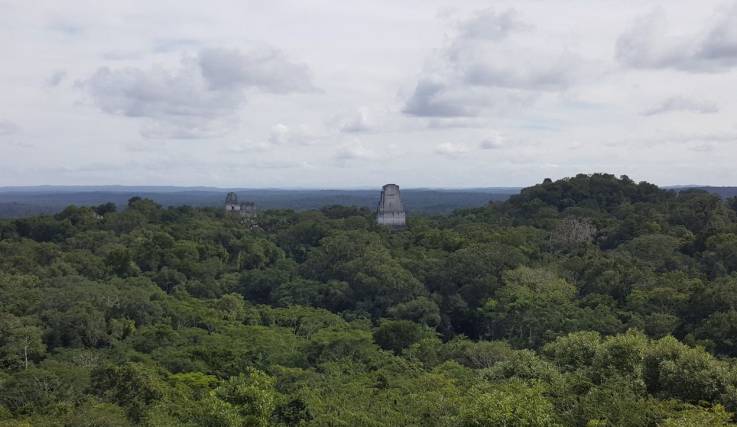
An aerial view of Tikal. Photo courtesy of Marcello Canuto.
“As an archaeology remote sensing expert, I have been using satellite imagery for years trying to locate sites under the dense jungle canopy,” Francisco Estrada-Belli, also a professor of anthropology at Tulane University, told artnet News in an email. “When I learned about LiDAR, I was skeptical initially because it looked like it could only map small areas. Then we learned that with the right amount of money—many times more than what we can raise for a single-season expedition—we might map a very large area in a matter of days.”
Canuto and Estrada-Belli were among the lead researchers on the groundbreaking LiDAR project launched by Pacunam. As a Maya cultural heritage foundation that works with a large number of Guatemalan archaeological sites, Pacunam was the perfect organization to oversee a project of this magnitude.
“Most researchers are interested in their own particular site and the area around it, and LiDAR is pretty expensive,” explained Canuto. “For an individual researcher to say, ‘Hey, give me a half-million dollars or a million dollars to cover this whole massive area over which I do not have any permit to do any research,’ would not have worked. Pacunam was the perfect entity to be able do LiDAR in these different regions and then coordinate the results.”
Based on the results at Caracol, and other sites surveyed with LiDAR, archaeologists were expecting to be able to identify new architecture elements built by the Maya. “The technology is fabulous,” said Chase. “We knew they were going to find all kinds of interesting stuff.” But no one could have predicted just how extensive the findings would be.
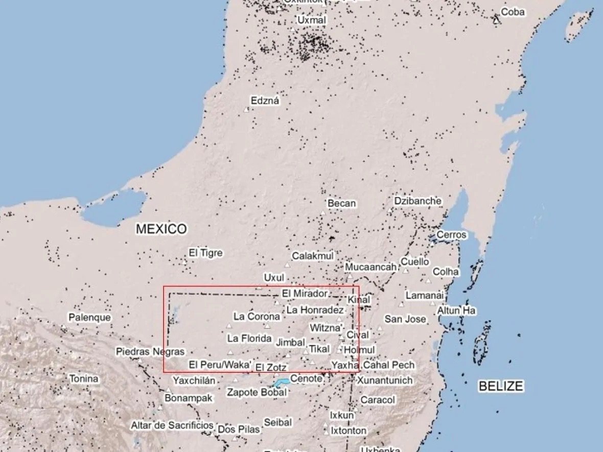
The Pacunam LiDAR Initiative scanned the Maya Biosphere Reserve in northern Guatemala, finding tens of thousands of previously unknown ancient structures. Image courtesy of Francisco Estrada-Belli/Pacunam.
Remarkably, a digital landscape generated of an 810-square-mile area of the Maya Biosphere Reserve in Petén, Guatemala, revealed no less than 61,000 unidentified ancient Maya structures that were invisible to the naked eye because of overgrown vegetation. What experts had mistaken for unusable swampland, for instance, had actually been farmland, crisscrossed with canals.
Seeing so many previously unknown roads, irrigation systems, defense fortifications, and other buildings, scholars started reevaluating their estimates as to how many people lived in the region—instead of five million, Petén may have been home to a population of up to 10 or even 15 million people.
“We knew the Maya were a complex and sophisticated civilization,” said Estrada-Belli, but “the size, density, and complexity of cities and the amount of landscape infrastructure the Maya built was just astonishing.”
The day the LiDAR data arrived, Canuto and Estrada-Belli had plans to attend a conference. Instead, they couldn’t tear themselves away from the computer, waiting with bated breath as a team at the University of Houston uploaded files with two gigabytes of data to a shared cloud.
“It was just one surprise after another,” Canuto recalled. “We couldn’t get enough of it.”
“We started looking around at 2 p.m. By 8 p.m., there were maybe 15 or 20 students in our lab, staring at these images we were getting,” he added. “I remember telling the students, ‘Remember this day, because this is the day that lowland Maya archaeology really changed.'”
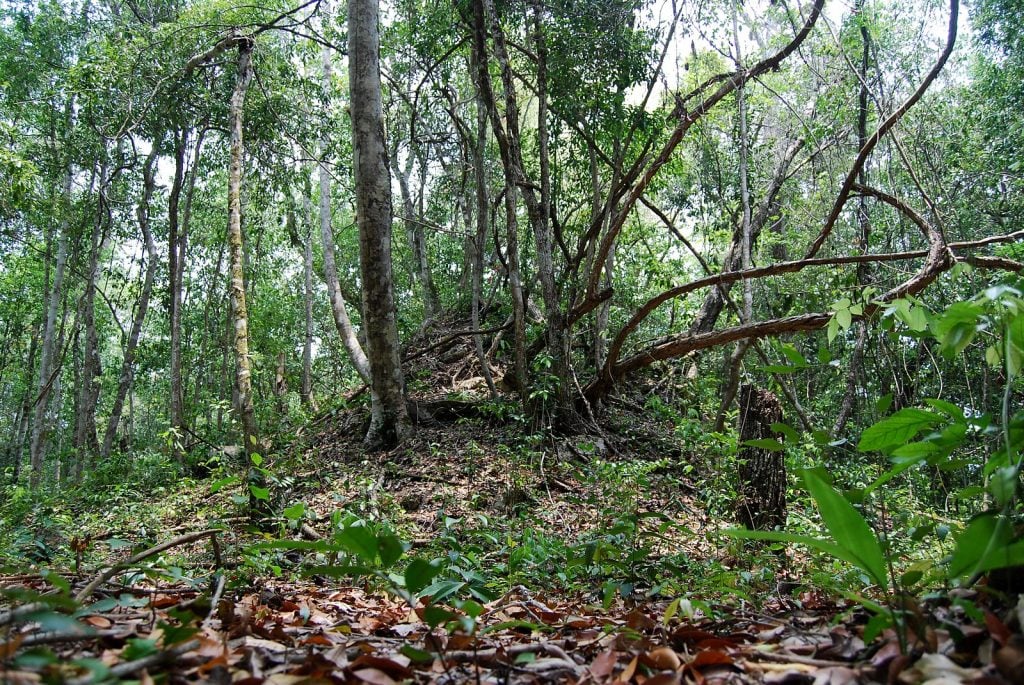
Buried temple, Maya Biosphere Reserve, El Petén. Photo by Geoff Gallice, Creative Commons Attribution 2.0 Generic license.
When Canuto and his co-authors published Pacunam’s findings in the journal Science last September, the news was widely covered in the media. But for the men and women who have dedicated their lives to the study of the Maya civilization, it was a game-changer.
Whereas before, archaeologists could only see what was right in front of their faces, LiDAR allows them to zoom out, taking in large regions at once. Quite simply, it would be impossible to replicate the scale of the Pacunam LiDAR scans on foot. After being hamstrung for decades by the time-consuming process of exploring the jungle on foot—discoveries were necessarily limited by how much ground could be physically covered by foot—researchers suddenly had mountains of data at their disposal.
“When you’re in the jungle, you’ve got five to 10 meters of visibility all around you,” explained Canuto. “Sometimes you can entirely miss things. It’s not as if, oh, at 100 meters away something looks small, but I can tell it’s something. At 100 meters away, you’re not seeing it at all, whether it’s big or small. Unless you get within 10 meters of that building, you’re just not going to see it.”
That’s particularly true for things that are large, but flat, like causeways, terraces, and roads—linear features that at first glance might be mistaken for natural elements of the landscape, but that LiDAR can identify with great accuracy. The prevalence of these structures seems to disprove previously held notions that Maya society consisted of disconnected city-states.

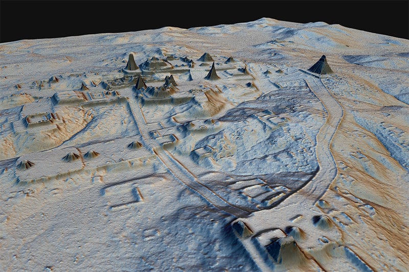
A LiDAR scan of the ancient Maya city of Tikal. Image courtesy of Marcello Canuto/PACUNAM.
“We’ll be able to talk about urbanism, population size, and demographic changes in ways that we’ve never been able to before,” said Canuto. “[The LiDAR findings] gives rise to the notion of sociopolitical and economic complexity and integration [among that Maya] in a way that perhaps 20 years ago we would have been uncomfortable declaring.”
And as archaeologists set about to confirm the accuracy of the data provided through ground-verification, their efforts to map the dense jungle groves are targeted better than ever before. “Instead of striking out into the forest blindly or on a hunch, we now know what to expect,” said Canuto. “There were lots of things shown by the LiDAR we had never noticed before, so we want to visit and see what in the world they might be.”
Of course, knowing the location of Maya ruins ahead of time does rob the field of some of some of its cinematic romance, Canuto admits—”the intrepid explorer going off in the jungle and finding the lost city; all that kind of mythology.” But he maintains that the scientific possibilities opened up by this technology are more than exciting enough to make up for that.
And just as important as revealing where unknown structures were built, LiDAR also shows the empty spaces, the areas where the Maya left the landscape empty. That might not seem significant, Canuto said, but consider New York: “Knowing that there’s a big empty space in the city known as Central Park is critical to understanding the nature of Manhattan.”
A topographical map of ancient Maya cities in northern Guatemala created with LiDAR scanning of the jungle. Image courtesy of the American Association for the Advancement of Science.
“Everybody wants LiDAR scans, but the problem initially was the cost, and convincing people to spend the money,” said Chase. The initial project at Caracol, which was funded by NASA, cost $171,000 dollars. “That’s a lot of money for a Maya archaeology project to spend, but it’s so economical compared to the amount of labor we invested trying to map on the ground, and it’s much more comprehensive.”
Consider, for instance, the city of Tikal in Guatemala, one of the best-known ancient Maya sites and part of the Pacunam LiDAR Initiative. Over the 1960s, ’70s, and ’80s, archaeologists there created “one of the largest and most celebrated maps of a Maya city,” said Canuto. “Let’s be generous, maybe there were 30 square kilometers [11.5 square miles] of mapping in and around it Tikal over the last half century. Around Tikal, this LiDAR we did, covered 150 square kilometers [58 square miles]. We quintupled the amount of area that was mapped around Tikal in one summer.”
“We’re no longer talking about a small data set that we hope is representative of a much larger phenomena. We now have a large data set that is statistically representative,” Canuto added. “The more we do LiDAR, the more representative it will be.”
Other archaeologists are benefitting as well around the world, particularly in Southeast Asia at Angkor Wat, which did LiDAR scans in 2016. “It’s not just a Maya phenomena,” said Chase. “It’s a worldwide phenomena.”
Knowing exactly where these ancient sites are can also help protect them moving forward. Investigating the LiDAR findings, said Estrada-Belli, “we also learned the extent of the damage looters had done over the years in Guatemala. Literally hundreds of thousands of looting pits have been counted.”
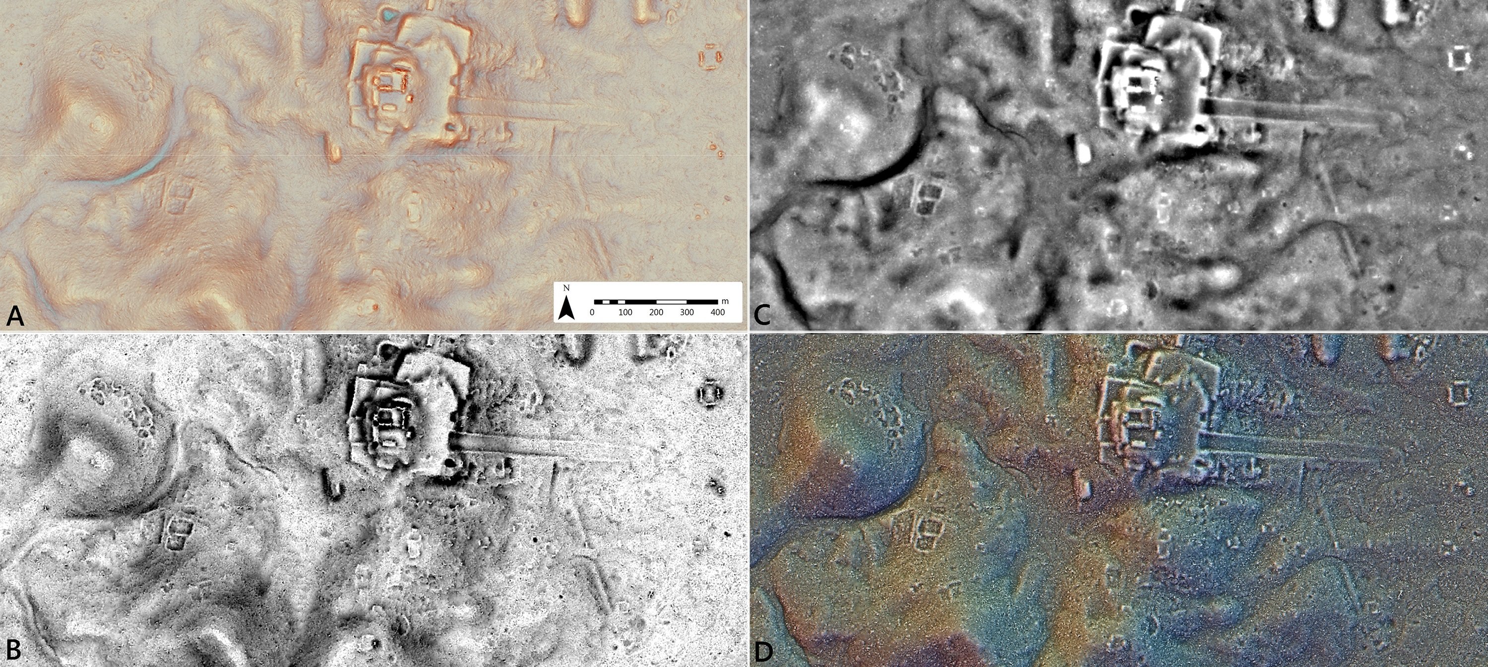
Visualizations used for LiDAR analysis. (A) Red Relief Image Map (RRIM); (B) Sky-View Factor (SVF); (C) Simple Local Relief Model (SLRM); (D) Prismatic Openness. Image courtesy of Marcello Canuto.
Both Chase and Canuto liken the impact of LiDAR to that of carbon-14 dating, which allowed archaeologists to accurately date artifacts for the first time, identifying their exact ages, not just relative to other objects. What radiocarbon dating does for the archaeological timeline, LiDAR does for physical space.
But LiDAR isn’t the only way in which archaeology has changed dramatically in recent decades. Artifacts are being analyzed by 3-D scanning. “Just like LiDAR, it is a new de facto standard in documenting antiquities,” said Estrada-Belli. Sites are being photographed, documented, and mapped at new, previously inaccessible angles thanks to drones. Scientists can test bones to determine what people and animals ate, or do a chemical residue analysis to figure out what kinds of activities might have been carried out at a given location.
“All of those technologies are part and parcel of the arsenal now,” said Canuto, marveling over the tools available to him now versus 30 years ago. “They usually come from other parts of the sciences, and we’re just applying them to Maya archaeological research.”
As a teenager on his first dig back in 1985, Canuto discovered a rib bone that turned out to be the oldest example of Maya writing known to that point. It took two years to get an epigrapher to analyze the hieroglyphs and decipher the ancient script. The bone had to be photographed, the markings copied in a drawing, and the images mailed off to the expert, a process that would take months.
Today, thanks to digital photography and the internet, archaeologists can get these types of answers in hours. “Despite the fact that I am in the middle of the jungle in Guatamala,” said Canuto, “satellite technology is allowing me to do real-time decipherment of objects that are just out of the ground. The presumption is that we’ll be able to decipher any text that we might find. In 1985, it was a big shoulder shrug!”
“Some people might regret that we’re not isolated in the jungle the way they were in the 1960s and ’70s,” he added. “But sometimes that kind of isolation is not so good for your intellectual development.”
And despite the massive impact of LiDAR, plenty of mysteries remain for archaeologists to solve. “What LiDAR doesn’t give us is depth, the things under the ground, so there are plenty of discoveries to be made,” said Canuto. “Who knows what technology can come up with next!”