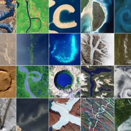
No, these wildly-colorful images aren’t abstract paintings. The US Geological Survey has released the fourth installment in its stunning “Earth As Art” series, selected from the very best of the 700-odd daily images taken by Landsat 8, a satellite that makes its way across the world every 16 days.
“At first glance, science and art might seem like an unlikely pairing. Yet throughout history, the intersection of these two fields has often resulted in science-based works of sublime beauty,” wrote the USGS in an announcement about the 37 new photographs.
Since 1972, the Landsat satellites have kept a visual record of the planet’s changing landscape, showing how our coastlines, continents, and islands have been altered over the years, both through natural and human impact. The “Earth as Art” series began in the late 1990s, when staff at the USGS’s Earth Resources Observation and Science (EROS) Center began collecting the best images beamed back from the satellite.
“Every once in a while we’d see an image that was so amazing, so remarkable, that we started squirreling them away,” said EROS engineer Jon Christopherson in a statement. “It wasn’t long before we had a drawer full of spectacular images.”
Earth’s Aquarium, “Earth as Art,” September 22, 2014.
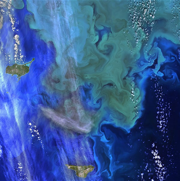
These green and blue swirls in the Bering Sea reveal the bottom of the food chain in the ocean. Microscopic organisms called phytoplankton, which are important to fish populations, may be too small to be seen individually, but in vast numbers they are visible from space. The white clouds in the image look like bubbles in an aquarium.
Photo: USGS.
Taken from the far remove of space, Landsat images offer a unique perspective on the Earth and its geological features, which can appear strikingly beautiful from above. The unexpected patterns and vivid colors featured in Landsat photography could just have easily sprung from the easel of a great artist.
The first “Earth as Art” photo set was released in 2002, and the images were printed and displayed across the world, including at Capitol Hill and the Library of Congress.
The current Landsat 8 satellite was launched in 2013, and the latest batch of photographs were released by the USGS in March. The photos will be the subject of a travelling exhibition, which will first be displayed at the USGS Headquarters in Reston, Virginia.
See images from the fourth installment of “Earth As Art” below:
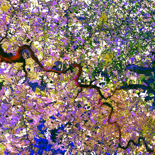
Tessera Mosa, “Earth as Art,” September 2, 2014.
The Tietê River snakes across this tessera mosaic of multicolored shapes near Ibitinga, Brazil. Fields of sugarcane, peanuts, and corn vary in their stages of development. Lavender, purple, and bright blue indicate actively growing crops. Light yellow or white indicate little or no vegetation growth. The splotches of dark mustard yellow are urban areas.
Photo: USGS.
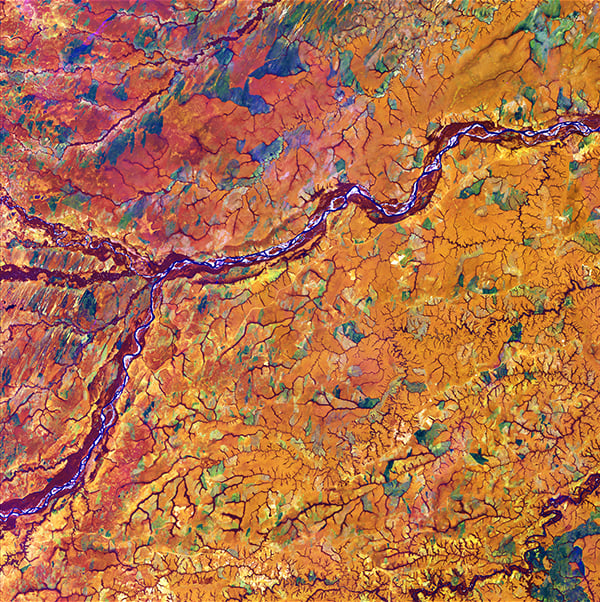
Capillaries, “Earth as Art,” January 28, 2014.
Marking part of the boundary between Colombia and Venezuela, the Meta River resembles an artery among capillaries within the human body. Those capillary-like features actually depict dense tree cover along the numerous streams that flow among rich tropical grassland.
Photo: USGS.

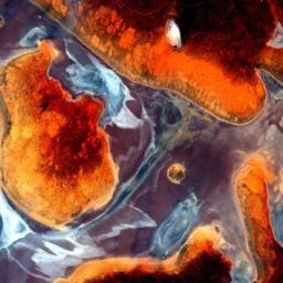
Melted Colors, “Earth as Art,” December 5, 2014. Br>This enhanced image of Western Australia resembles a mixture of crayons that melted in the sun. The yellow sand dunes of the Great Sandy Desert cover the upper right portion of the image. Red splotches indicate burned areas from grass and forest fires, and the colors in the rest of the image depict different types of surface geology.
Photo: USGS.
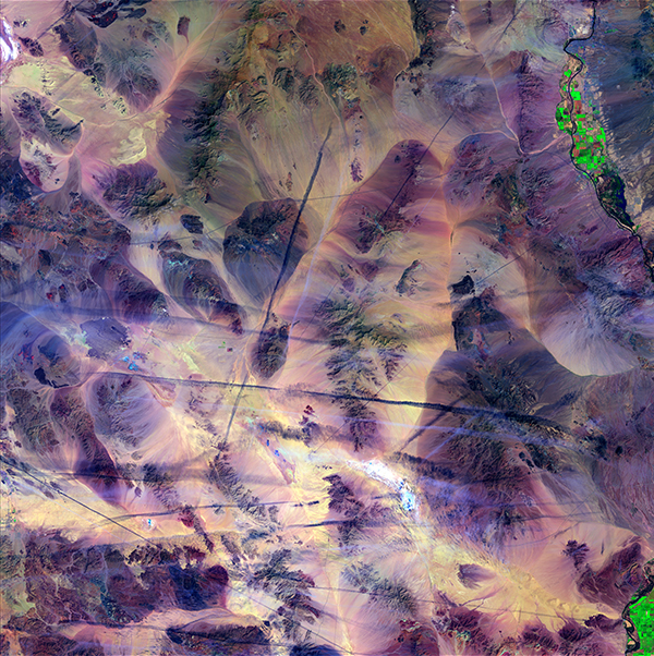
Contrails, “Earth as Art,” April 3, 2015.
Like scratches on a marble table, airplane contrails cut across the southern California Mojave Desert. The shadows from the contrails cast dark lines across the ground. Contrails form when cold, dry air mixes with warmer aircraft exhaust. Mountains and a few dry lakebeds provide a backdrop to this scene, along with bright green spots of agriculture along the Colorado River.
Photo: USGS.
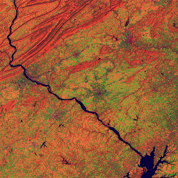
River and Ridge, “Earth as Art,” April 24, 2014.
The Susquehanna River appears as a dark line coursing through this scene in southeastern Pennsylvania. The cities of York, Lancaster, and Reading lie among agricultural lands. The State capital, Harrisburg, is positioned against the orange folds in the upper left of the image, along the edge of the Appalachian Mountain Ridge and Valley Province.
Photo: USGS.
Eerie Cloud Shadows, “Earth as Art,” March 22, 2014.
These cloud patterns cast eerie shadows on the landscape of southern Egypt. The clouds appear red and the desert below hazy blue in this infrared rendition.
Photo: USGS.
“Earth as Art,” June 24, 2014.
The ice surrounding the northern Canadian Spicer Islands, shown in bright red, resembles a cell, complete with ribosomes, mitochondria, and a nucleus. Even though the image was captured shortly after the first day of summer in the Northern Hemisphere, the islands are locked in ice.
Photo: USGS.
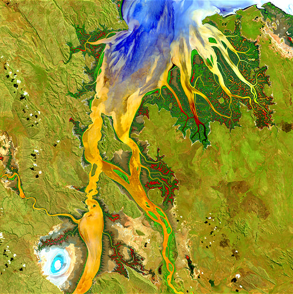
Nature’s Patterns, “Earth as Art,” May 12, 2013.
The biologically complex conditions of mangroves are shown in dark green along the fingers of the Ord River in Australia. Yellow, orange, and blue represent the impressive flow patterns of sediment and nutrients in this tropical estuary. The bright spot at the lower left is an area of mudflats, which is home to saltwater crocodiles.
Photo: USGS.
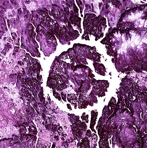
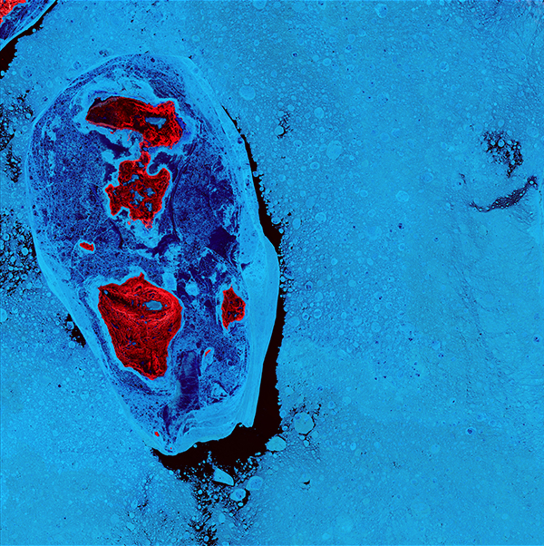
Eye of Quebec, “Earth as Art,” March 28, 2015.
Lake Manicouagan, Canada, is one of the Earth’s largest and oldest known impact craters. The crater is 65 kilometers (40 miles) wide and is estimated to be about 214 million years old. The lake and island are clearly seen from space and are sometimes called the “Eye of Quebec.”
Photo: USGS.
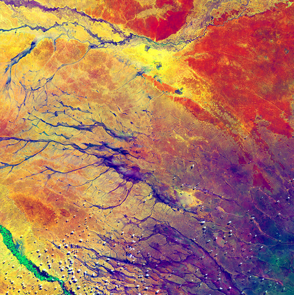
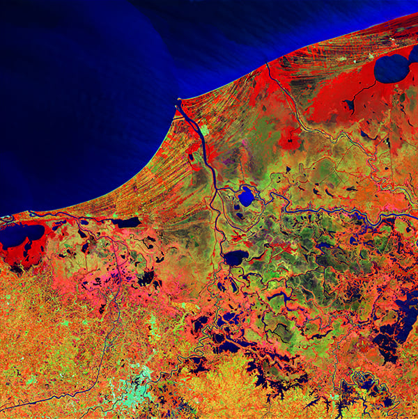
A Study in Color, “Earth as Art,” July 15, 2014.
The deep purple in the lower right spreads out into a few channels before fading into a multitude of colors. These channels are remnants of an ancient drainage network in Kenya. The beauty of the colors actually hides a stark reality for hundreds of thousands of people. The dark spots at the top center of the image are refugee camps.
Photo: USGS.
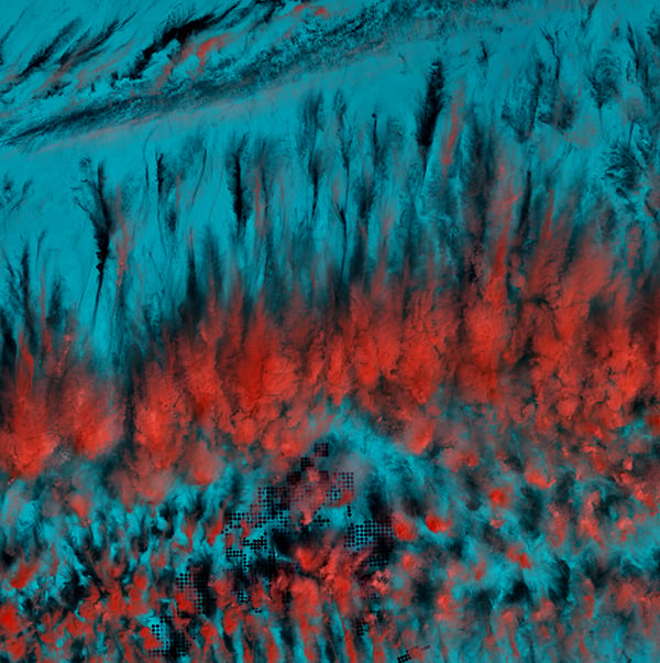
Cloud Lightning, “Earth as Art,” October 4, 2014.
What looks like lightning arcing through an ominous cloud is actually a dry landscape of rocky buttes in southern Utah and northeastern Arizona. River channels flow north from Arizona into the San Juan River. The light vertical feature at the top of the image is referred to as Comb Ridge, a jagged fold in the Earth’s crust called a monocline.
Photo: USGS.
Mexico’s Biosphere, “Earth as Art,” February 20, 2014.
Much of this image consists of the Reserva de la Biosfera Pantanos de Centla, a biosphere reserve in southern Mexico that protects wetlands in the area. The water bodies, mangroves, and forests are a sanctuary for a great variety of wildlife. Sediment carried away by the Grijalva River appears as a sweeping light blue brushstroke flowing into the Gulf of Mexico at the top of the image.
Photo: USGS.
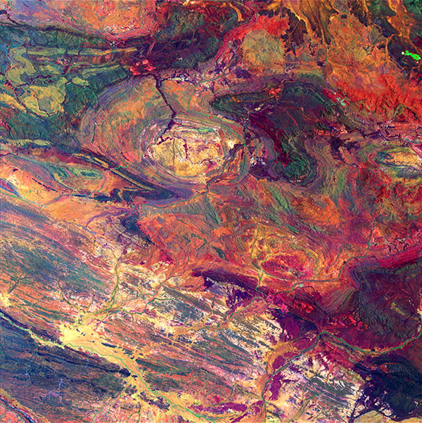
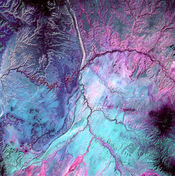
Australian Iron Ore, “Earth as Art,” December 19, 2014.
Within the Hamersley Iron Province in Western Australia, Landsat’s shortwave infrared and near-infrared detectors highlight different types of rock. The oval in the upper center part of the image is a geological feature called Rocklea Dome. The dark meanders within the dome are channel iron deposits.
Photo: USGS.
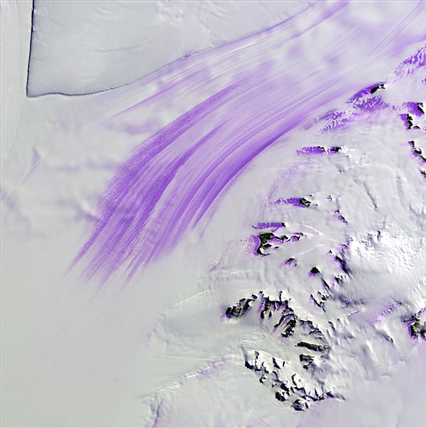
Slessor Glacier, “Earth as Art,” November 14, 2014.
Slessor Glacier in Antarctica flows between the angular promontory Parry Point on the top left of the image and the Shackleton Range on the lower right. The purple highlights are exposed ice. Strong winds blow away the snow cover and expose lines that indicate the glacier flow direction. Rock outcrops next to the glacier also exhibit some of this bare ice.
Photo: USGS.