Art World
We Revisited the Scenes of 8 Iconic Photographs on Google Street View to Capture What Has—and Hasn’t—Changed
While some places look much the same, others are quite different.
 on the left, bleeding into an image from Google Street View.")
While some places look much the same, others are quite different.
Taylor Dafoe
 ShareShare This Article
Great photographs freeze forever a singular interaction of time and place. The best ones permanently define our sense of a site. Who can imagine, for instance, the granite cliffs of Yosemite National Park without conjuring up Ansel Adams’s romantic pictures? It doesn’t matter that there are countless photos by others; Adams’s cliffs are the ones we tend to see in our mind’s eye.
Places change, though, and so do our means of documenting them. Whereas Adams lugged cumbersome cameras up craggy mountainsides, today, hikers have it much easier, needing only a well-marked trail and the phones in their pockets. In fact, you don’t even need to leave the computer screen you’re looking at now to see the world, thanks to Google. Just check out Google’s Street View platform, plug in an address, and boom—you’re there.
Indeed, Google’s glitchy depictions of the world have changed the way we think about the landscape. To demonstrate this, we picked out a selection of famous photographs from the last 100 years and revisited them through Google. A lot has changed. Formerly gritty New York streets are today lined with chain stores and pharmacies, and the Las Vegas Strip, once covered in neon signage, is today home to marijuana dispensaries and shooting ranges catering to bachelorette parties.
But it’s not all different. In the backgrounds of many Google Street View shots are remnants of the world as it once was. Here are eight striking examples.
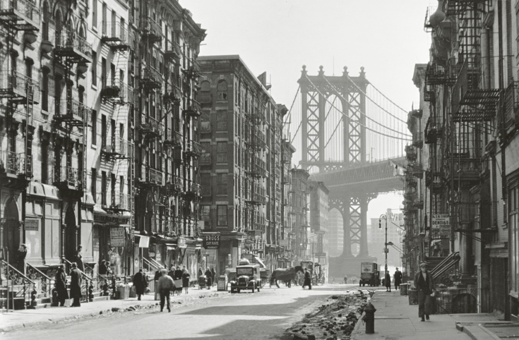
Berenice Abbott, Pike and Henry Streets, March 6 (1936).
In the late 1920s, Berenice Abbott closed her portrait studio in Paris and relocated to New York with the goal of documenting the rapidly changing American city. She shot thousands of photographs for her Changing New York series over the next decade, and many of her pictures are still counted among the most iconic images of Gotham ever made. Affordable housing units and hotels have drastically changed the identity of the streets where Abbott took this picture, but the Manhattan Bridge appears unchanged.
Location: The corner of Pike Street and Henry Street, New York
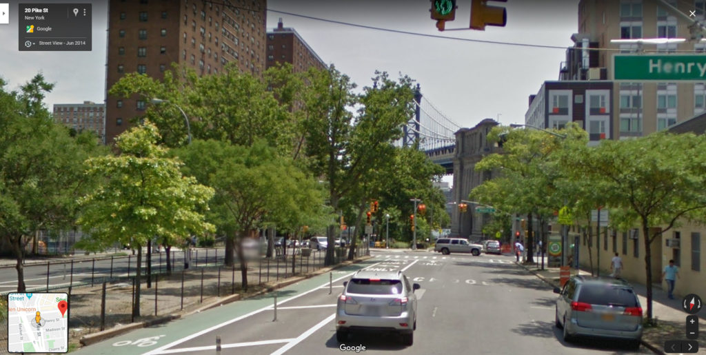
The corner of Pike Street and Henry Street, New York. Courtesy of Google Street View.
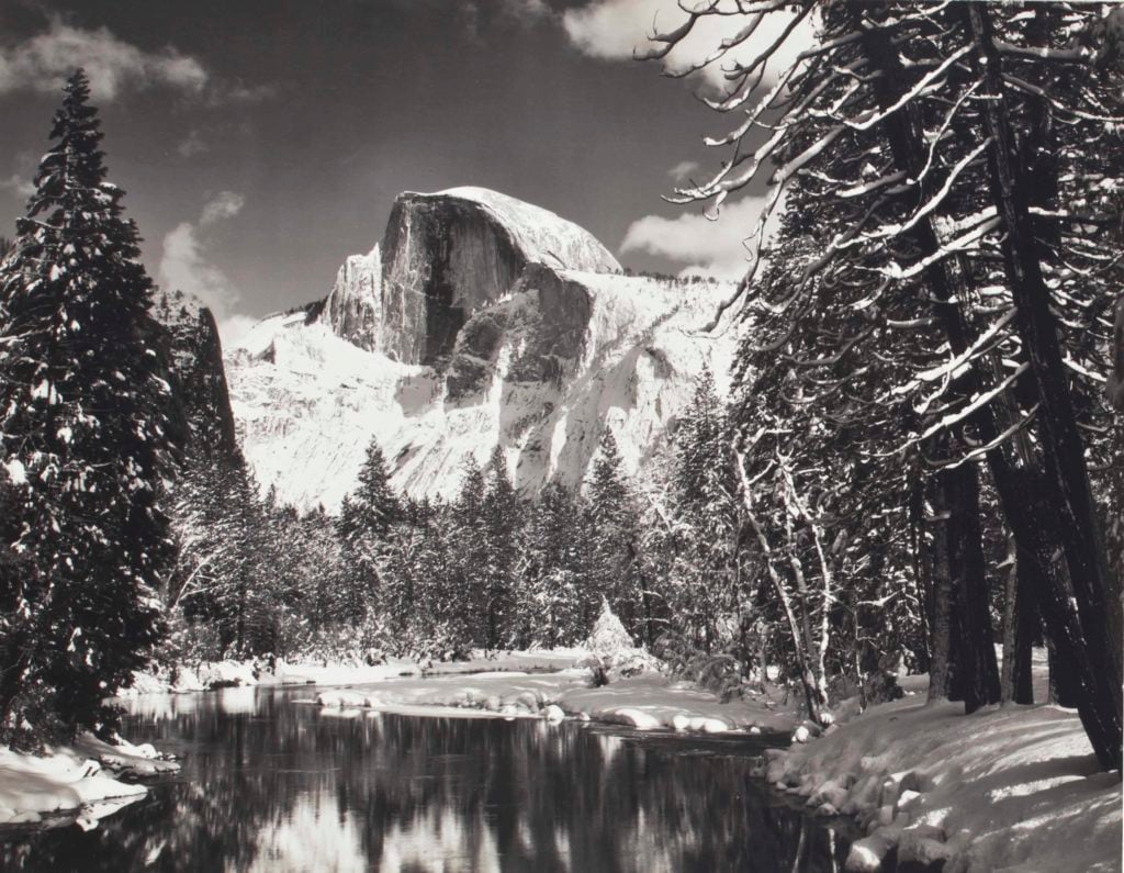
Ansel Adams, Half Dome, Merced River, Winter, Yosemite National Park (1938).
Half Dome, a rounded rock formation in Yosemite National Park, was one of Ansel Adams’s favorite subjects, and he considered his dramatic 1927 image of the mountain to be his “first really fine photograph.” Unfortunately, not every Adams photograph can be found on Google Street View. So we’ll have to settle for the artist’s oft-reproduced 1938 take on the landmark. Since the picture was taken, a bridge over the winding Merced River was erected at almost the exact spot where Adams took his picture.
Location: Sentinel Bridge, Yosemite National Park, California
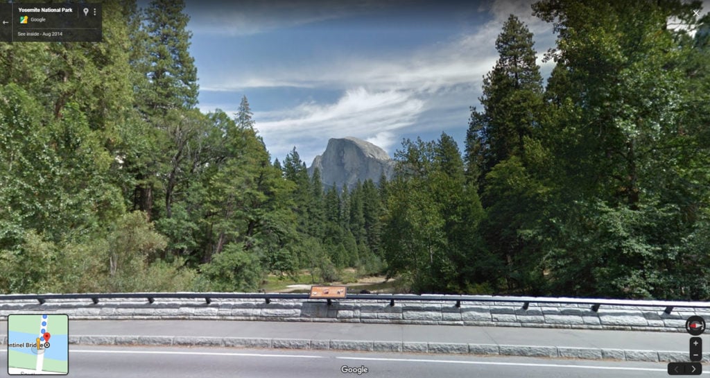
Sentinel Bridge in Yosemite National Park, California. Courtesy of Google Street View.
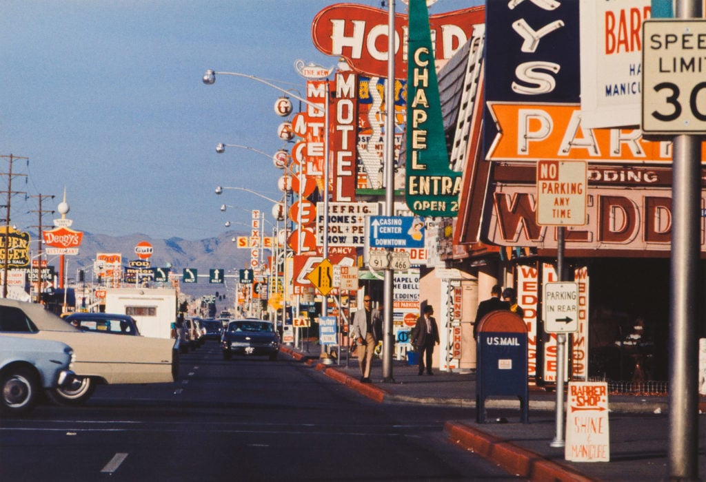
Denise Scott Brown, Architettura Minore on the Strip, Las Vegas (1966).
In their landmark book Learning From Las Vegas: the Forgotten Symbolism of Architectural Form, Denise Scott Brown and her partner Robert Venturi used the Las Vegas Strip to tell the story of vernacular architecture. An architect more than an artist, Scott Brown turned to the camera as a means of illustrating her theories. But the resulting photographs—dense with campy advertisements, animal-shaped structures, and mid-century neon signage—are compelling artifacts themselves. Today, where Scott Brown took one of the most well-known photos from the series, a street-level shot of “motel row,” there is a cannabis dispensary and a shooting range.
Location: The corner of South Las Vegas Boulevard and West Cinncinati Avenue, Las Vegas
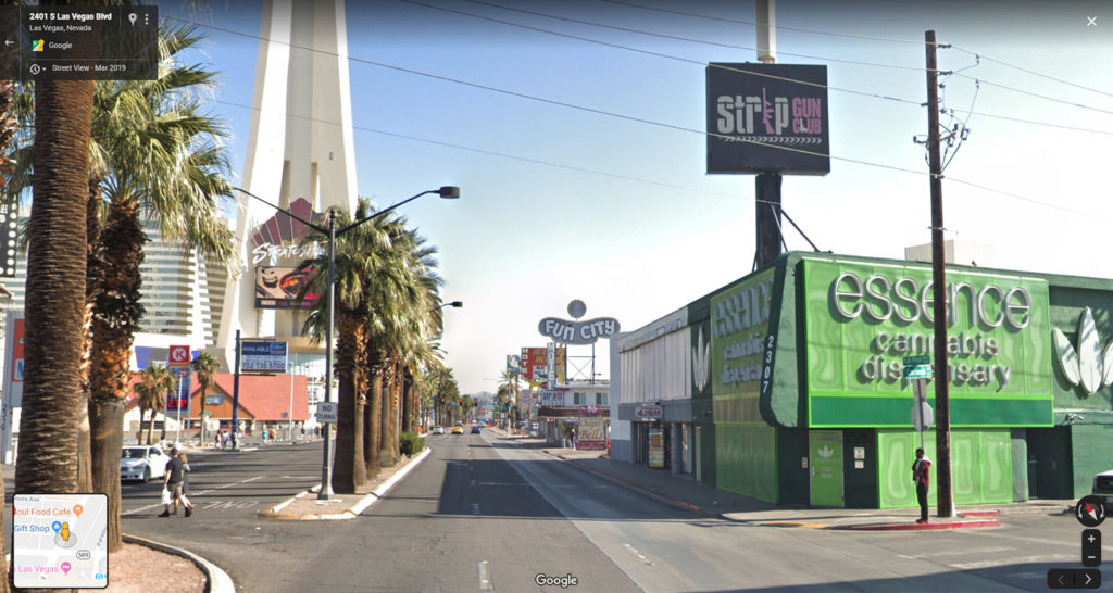
The corner of South Las Vegas Boulevard and West Cincinnati Avenue. Courtesy of Google Street View.
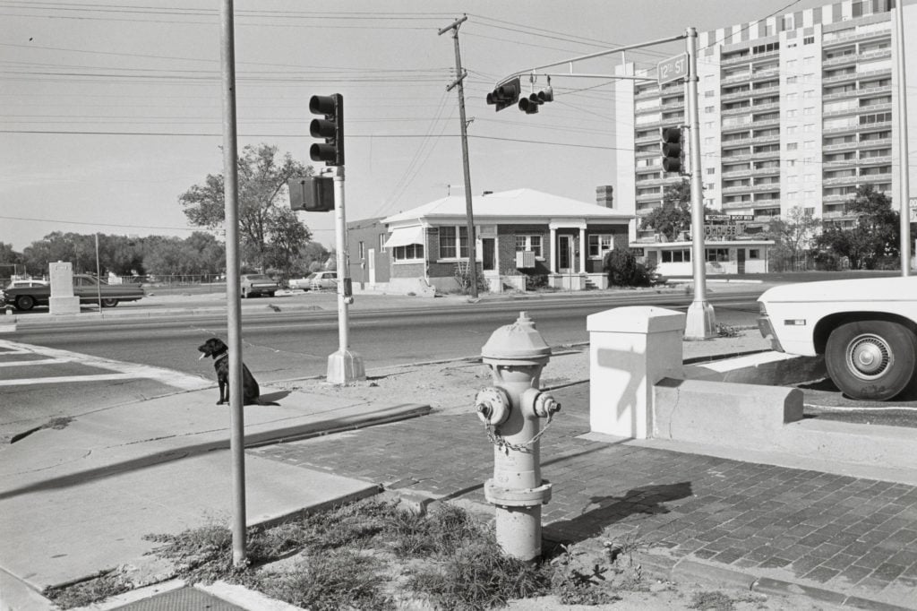
Lee Friedlander, Albuquerque, New Mexico (1972).
“Somebody else could walk two feet away to get those poles and trees and stuff out of the way,” Lee Friedlander said in a 1987 interview with fellow photographer William Gedney. He was describing his penchant for framing his pictures with objects in the foreground—a technique on display in this wry shot of a street corner in Albuquerque. “I almost walk two feet to get into it, because it is part of the game that I play, it isn’t even conscious.” Not much has changed on the corner of Central Avenue and 12th Stret since Friedlander was there. The Dog House Drive-In (in the far right of Friedlander’s shot) is still there.The actual dog, sadly, is not.
Location: Central Avenue and 12th Street, Albuquerque
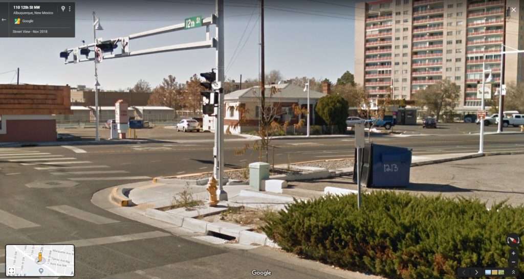
Central Avenue and 12th Street, Albuquerque. Courtesy of Google Street View.
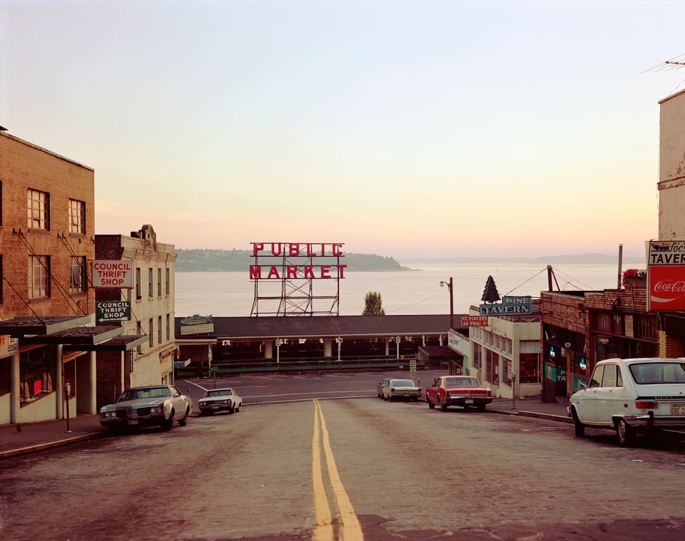
Stephen Shore, Pine Street, Seattle (1974).
This article could have been dedicated exclusively to Stephen Shore photographs, considering how much material we would have to work with. (The photographer himself recently took on a similar exercise on his Instagram.) One of the masters of the modern landscape, Shore helped to reinvigorate the genre of diaristic road-trip photography, picking up where Robert Frank left off a generation prior. Shore was also instrumental in making color photography into a fine-art form along the way. This simple picture of Seatle’s Pine Street is a prime example. Today, the scene looks largely the same.
Location: Pine Street and Pike Place, Seattle
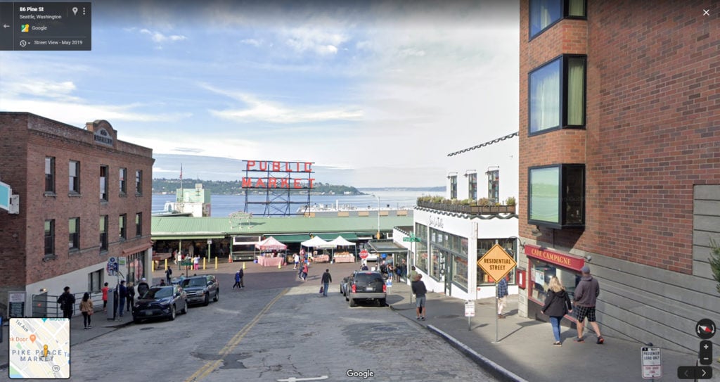
Pine Street and Pike Place, Seattle. Courtesy of Google Street View.
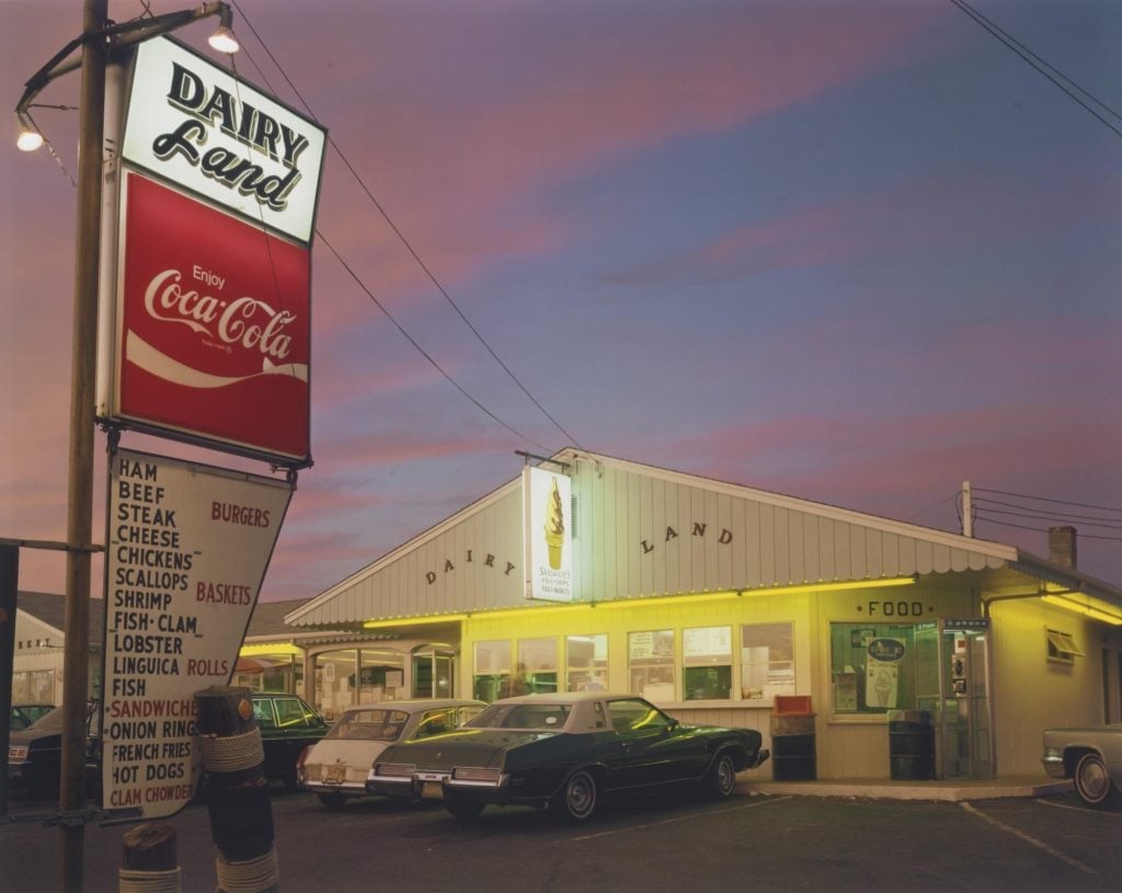
Joel Meyerowitz, Dairyland, Provincetown, Cape Cod (1976).
The late-summer light of Cape Cod has long been fascinating to Joel Meyerowitz. In this picture—included in his landmark 1979 book, Cape Light, you can see why: the cotton-candy marble of the sky at dusk is surreal against an ice cream shop’s fluorescent glow. The whole scene is like an Edward Hopper painting on mild psychedelics. Today, the ice cream store is no longer there, although there is a fish-fry joint just next door.
Location: 85-87 Shank Painter Road, Provincetown, Massachusetts
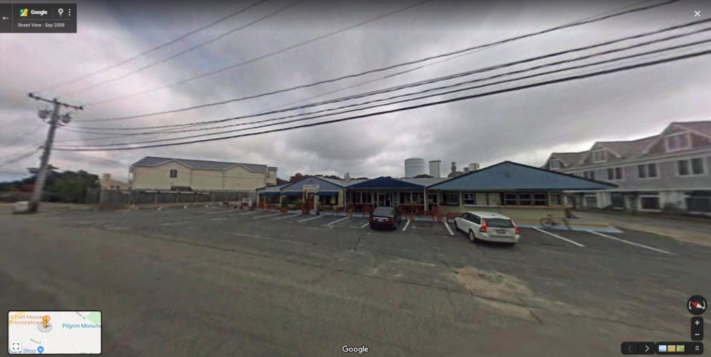
85–87 Shank Painter Road, Provincetown, Massachusetts. Courtesy of Google Street View.
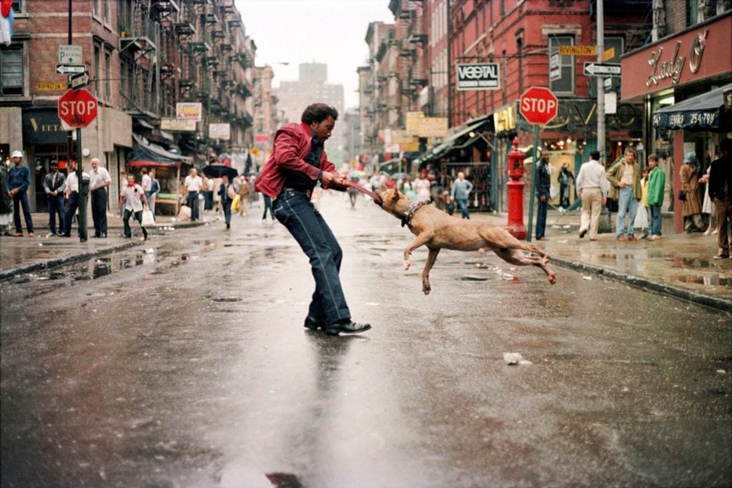
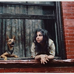
Jamel Shabazz, Man and Dog (1980).
Training his lens on boombox-carrying breakdancers, dapper fashionistas, and burgeoning hip-hoppers, Jamel Shabazz documented the streets of New York in the ‘80s. Man and Dog is perhaps his most recognizable image from this time. “I took [that photo] on Manhattan’s Lower East Side, down on Orchard Street,” he told Sleek magazine in 2015. “I spent so much time here, it was one of my favorite locations that I’ve shot over time and it looks nothing like this anymore. It’s changed so much there over time that this photograph becomes more like part of a visual diary.”
Location: The corner of Rivington Street and Orchard Street, New York
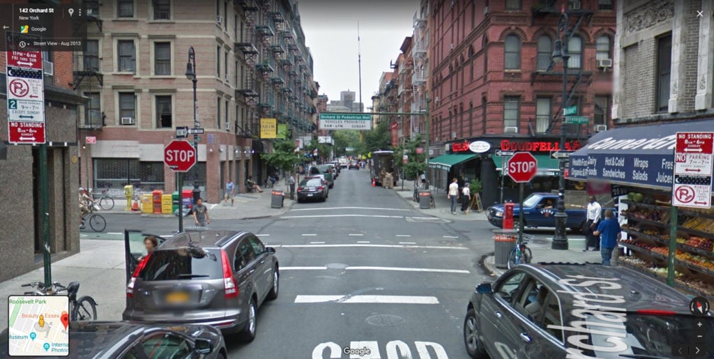
The corner of Rivington Street and Orchard Street, New York. Courtesy of Google Street View.
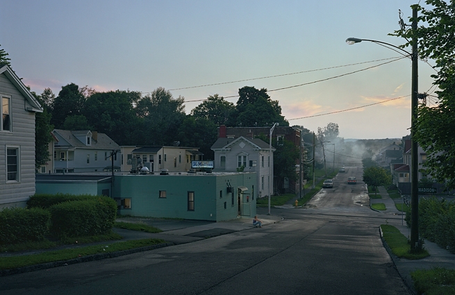
Gregory Crewdson, Untitled (The Madison) (2007).
Crewdson has turned to Western Massachusetts time and again for his surreal cinematic photographs. Pittsfield, an old industrial town in the Berkshires, was one of the main sites for his 2005 body of work, Beneath the Roses (the making of which was the focus of Ben Shapiro’s 2012 documentary, Gregory Crewdson: Brief Encounters). You can find a number of shots from the series on Street View, which reveals streets that are largely the same, even if Google’s cameras have none of the subtlety of Crewdson’s pictures.
Location: Madison Avenue, between Seymour Street and Madison Place, Pittsfield, Massachusetts
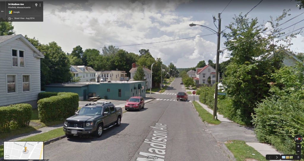
Madison Avenue, between Seymour Street and Madison Place, Pittsfield, Massachusetts. Courtesy of Google Street View.