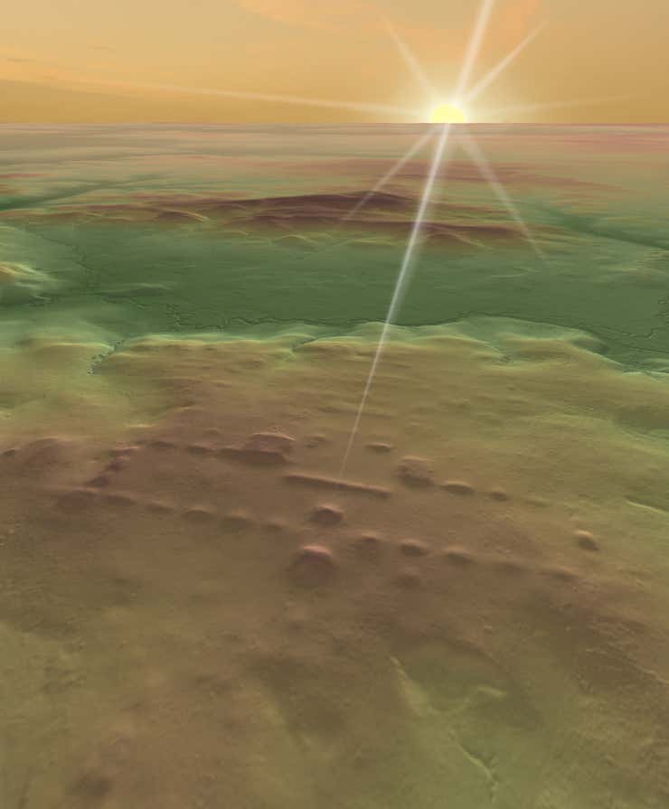
Archaeologists have discovered nearly 500 new Mesoamerican sites built by the Maya and the Olmec in Mexico thanks to groundbreaking Light Detection and Ranging, or LiDAR, technology.
Using laser pulses tied to a GPS system, LiDAR took topographical readings to create a three-dimensional map of a 30,000-square-mile area around eastern Tabasco. When archaeologists analyzed the data, they found evidence of 478 sites that would have been part of precolonial settlements between about 1400 B.C. and 1000 A.D., reports Gizmodo.
The findings, published in the journal Nature Human Behavior, showed that all of these sites included rectangular and square complexes, suggesting a shared culture based on the earlier Olmec city of San Lorenzo and its central rectangular plaza.
“The findings were surprising because most of these sites were not known before,” lead author Takeshi Inomata, an archaeologist at the University of Arizona, told Artnet News in an email. “This area is fairly open and populated. But because those sites are horizontally large and individual buildings are not tall, if you walk on a site, you do not notice its shape. They were hidden in plain sight.”
A LiDAR image of the sites of San Lorenzo (left) and Aguada Fénix (right) with similar long rectangular platforms surrounded by 20 smaller platforms. Image courtesy of Juan Carlos Fernandez-Diaz and Takeshi Inomata.
Some of the architecture appears to be constructed to align with the sunrise on certain days, or with nearby mountains, perhaps suggesting a symbolic meaning. Structures also appear in groups of 20—a number is also the basis for the written Maya calendar.
“We don’t have the written calendar at this time yet,” Inomata told Live Science. “[That] comes much later, several centuries later than these sites. But this is a very tantalizing sign that actually people already had a calendar system that’s based on the number 20.”
The large number of unknown sites identified by the mapping project serves as reminder at how useful LiDAR is at identifying manmade features in the landscape that aren’t easily accessible by foot, or might be obscured from view on the ground by vegetation.
The area of the LiDAR survey. Image courtesy of Takeshi Inomata.
“The study foreshadows the future for archaeology as LiDAR reveals ancient architecture at an unprecedented scale that will reach into remote and heavily vegetated regions the world over,” Robert Rosenswig, an archaeologist at the University of Albany-SUNY, wrote in an accompanying article for Nature, calling LiDAR “revolutionary for archaeology.”
LiDAR has been around for some time, but it took a few years before archaeologists were able to use it for their own ends. The team at Caracol, an archaeological site in Belize, pushed for four years to scan an 80-mile-area around the city. When they finally got the green light in 2009, they realized the Maya city stretched deep into the jungle, far beyond the known confines of the settlement.
Another major archaeological breakthroughs made using LiDAR came in 2018, when archaeologists in Petén, Guatemala, were able to identify 61,000 unknown structures in the Maya Biosphere Reserve thanks to the new technology. A single day with LiDAR data can provide information that it would take years if not decades to uncover on foot, in the dense underbrush.
Aguada Fénix, one of the areas included in the LiDAR scans, was probably a ceremonial gathering site from the Maya. Photo courtesy of Takeshi Inomata.
Inomata had previously used existing LiDAR maps commissioned by the Mexican government to find 27 lost Maya sites. Last year, he excavated the world’s largest and oldest Maya temple, at Aguada Fénix in Mexico, after locating the site in LiDAR scans. (Aguada Fénix is also covered in the new LiDAR scans.)
Other recent LiDAR discoveries include a new temple hidden at Tikal in Guatemala, one of the world’s most famous Maya sites, and a scan of the area around Mexico City that revealed the outlines of ancient Teotihuacán, as published last month in the journal PLOS One.
And, across the world, a long-running LiDAR research project in Cambodia recently helped determine that the ancient city of Angkor Wat, the world’s largest religious monument, once supported a population of up to 900,000 people.
Aerial view of the plateau at Aguada Fenix. Photo courtesy of Takeshi Inomata.
In the U.K., an aerial mapping project conducted by the National Trust on the Wallington Estate in Northumberland, England, just uncovered 120 new archaeological features. The organization began the project to help draw up plans for planting 75,000 British native trees on the 13-hectare estate. (The trust aims to plant 20 million trees by 2030 to help combat climate change.)
Creating a 3D digital map of the landscape allowed the trust to identify the site of historic woodlands that had been cleared in the mid-18th century, as well as former farming systems. The oldest prehistoric sites on the state identified through the LiDAR scans date back to as early as 2000 B.C.
“This is an exciting moment in the 5,000-year history of this special estate,” National Trust archaeological consultant Mark Newman said in a statement. “The LiDAR findings have shone a light on much more than we could have imagined so that we can better understand the history of the landscape to help inform plans for its future.”
In Mexico, Inomata hopes to follow up the latest LiDAR research with more on-the-ground work. “While we continue our excavations in eastern Tabasco, the investigation of other sites will require the involvement of many other archaeologists,” he told Artnet News.
See more photos from excavations conducted by Inomata and his team at sites identified by LiDAR below.
Excavation at Aguada Fenix. Photo courtesy of Takeshi Inomata.
Excavation at Aguada Fenix. Photo courtesy of Takeshi Inomata.
Excavation at Aguada Fenix. Photo courtesy of Takeshi Inomata.
Excavation at Aguada Fenix. Photo courtesy of Takeshi Inomata.
Site of El Tiradero on the San Pedro River. Photo courtesy of Takeshi Inomata.