Art World
Satellites Are Taking Data-Based Images of the Earth and the Colors Are Spectacular—See Them Here
The Landsat 8 captures the beauty of the earth below in surprisingly artistic satellite images.

The Landsat 8 captures the beauty of the earth below in surprisingly artistic satellite images.
Sarah Cascone
 ShareShare This Article
Experience Earth art as you’ve never seen it before in a stunning new set of satellite images that depicts the globe’s landscape in otherworldly hues. Last month, the United States Geological Survey released the fifth installment of the “Earth as Art” series drawn from imagery taken by the Landsat satellite program.
Unlike traditional photographs, satellite images are based on data—readings of light, from the visible to the infrared—that can be interpreted in many different ways. By assigning colors—red, blue, or green—to the different bands of light on the spectrum and combining them, you get a color composite image that can be dramatically different from how the scene would appear to the naked eye. (Some of the “Earth as Art” images are digitally manipulated further to enhance color or detail.)
The resulting images look more like abstract art than recognizable landscapes of the planet we call home—a spectacular example of just how amazing it can be when art and science intersect. The newly released series contains 24 images taken by Landsat 8, which launched in 2013.
Landsat 1, originally named the Earth Resources Technology Satellite 1, was launched back in 1972. Two years later, a data management field office, the Earth Resources Observation and Science Center (or EROS), was founded in order to process the satellite imagery being beamed back down to earth. Today, Landsat 7 and Landsat 8 continue to orbit the planet, transmitting hundreds of images a day, each capturing a 115-mile square section of the earth’s surface.
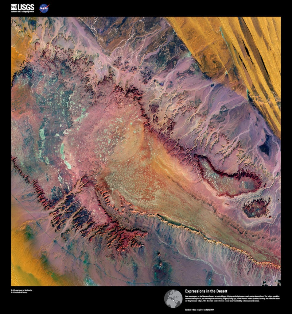
Landsat 8, Expressions in the Desert. In a remote part of the Western Desert in central Egypt, highly eroded plateaus rise from the desert floor. Image courtesy of US Geological Survey/NASA.
The striking images possess an undeniable aesthetic quality totally independent of their scientific value. That fact was recognized by EROS staffers tasked with image calibration in the late 1990s, who started setting aside any examples that were particularly extraordinary.
“Every once in a while we’d see an image that was so amazing, so remarkable, that we started squirreling them away,” recalled EROS engineer Jon Christopherson, in a statement for the series’ fourth edition, released in 2016. “We wrote them to CDs back then, and it wasn’t long before we had a drawer full of spectacular images.”
Eventually, the only logical thing to do was to put them on display. The first set of images debuted in 2001, ahead of the 30 anniversary of the launch of Landsat 1. An exhibition, “Earth as Art 1,” was held at the Library of Congress in Washington, DC, and stayed on view for three years between 2002 and 2005. Shows for the second and third editions followed, with the images entering the permanent collection of the library’s geography and map division.
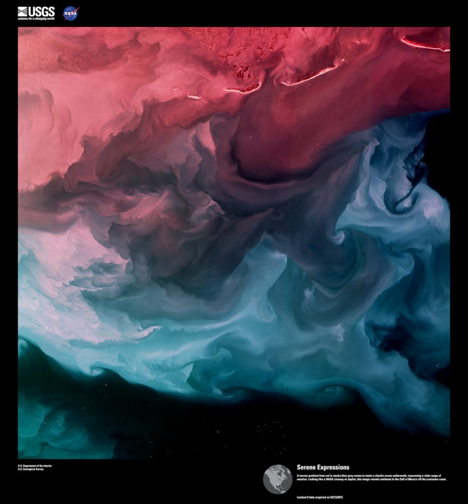
Landsat 8, Serene Expressions. A serene gradient from red to smoky blue-gray seems to mask a chaotic scene underneath, expressing a wide range of emotion. Looking like a NASA closeup of Jupiter, this image reveals sediment in the Gulf of Mexico off the Louisiana coast. Image courtesy of US Geological Survey/NASA.
In addition to its artistic qualities, the Landsat image archive serves as a vital historical record of the changing face of our planet since 1972, clearly showing physical alterations to the earth’s landscape due to both natural and human causes. The images taken by the satellites in the program can be of immense educational value and have had practical applications in the fields of agriculture, cartography, forestry, geology, surveillance, and regional planning.
“In essence, this archive of Landsat imagery is the equivalent of having a periodically refreshed family photo album for the entire earth, ” said Ghassem R. Asrar, NASA associate administrator of the office of earth science, in a statement about the first “Earth as Art.”
The EROS team has gotten particularly creative in naming their selections over the years. “The titles of the images in this fifth edition of ‘Earth as Art’ speak to the powerfully artistic qualities of earth’s natural features when tinged with unnatural colors,” notes the introduction, citing as examples the images Fanciful Fluorescence, Lurking Madness, and Serene Expressions. “Art serves as a great partner in the communication of science, bringing emotion to the pursuit of understanding.”
See more photos from “Earth as Art 5” below.
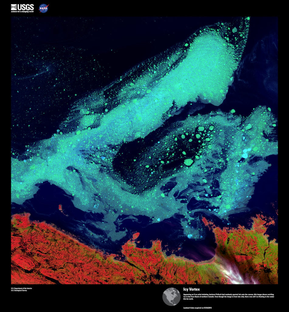
Landsat 8, Icy Vortex. Appearing as if an artist imitating Jackson Pollock had randomly spurted ink onto the canvas, this image shows swirling ice in the Foxe Basin of northern Canada. Even though the image is from late July, there was still ice floating in the water this far north. Image courtesy of US Geological Survey/NASA.
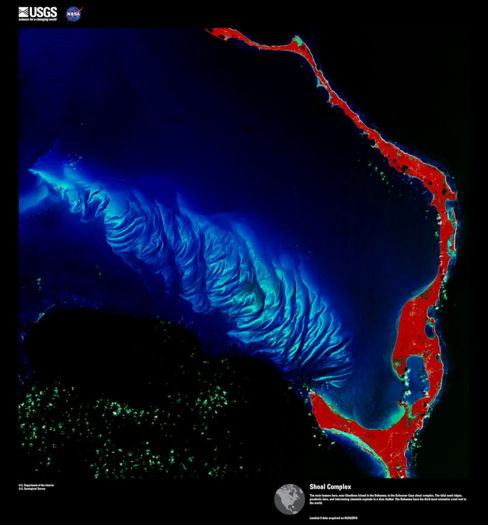
Landsat 8, Shoal Complex. The main feature here, near Eleuthera Island in the Bahamas, is the Schooner Cays shoal complex. The tidal sand ridges, parabolic bars, and intervening channels explode in a blue rhythm. The Bahamas have the third most extensive coral reef in the world. Image courtesy of US Geological Survey/NASA.
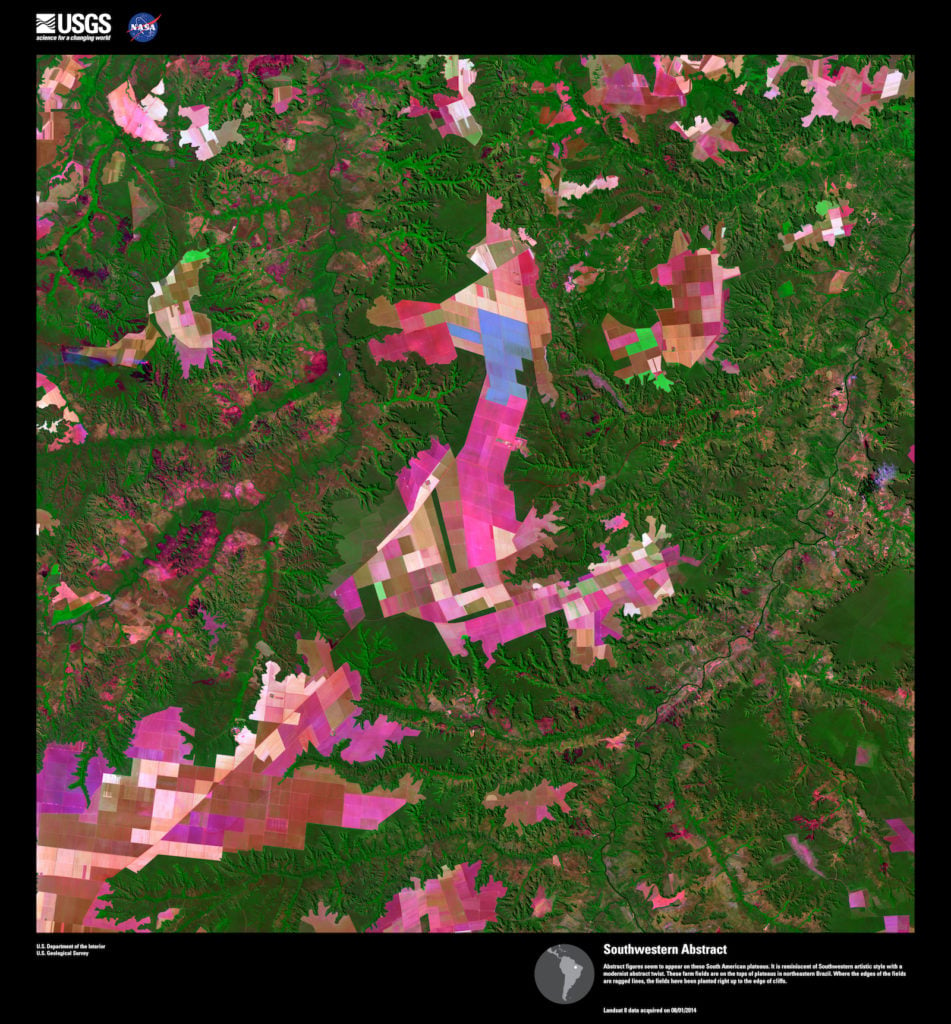
Landsat 8, Southwestern Abstract. Abstract figures seem to appear on these South American plateaus. It is reminiscent of Southwestern artistic style with a modernist abstract twist. These farm fields are on the tops of plateaus in northeastern Brazil. Where the edges of the fields are ragged lines, the fields have been planted right up to the edge of cliffs. Image courtesy of US Geological Survey/NASA.
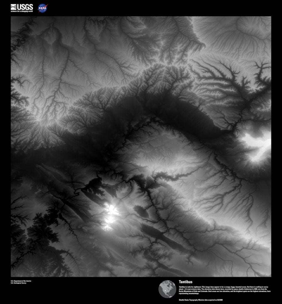
Landsat 8, Tantibus. Tantibus is Latin for nightmare. This image does appear to be a creepy, foggy, haunted scene. But there is nothing to worry about—it is just science data. The elevation data shown here, recorded by space shuttle Endeavour in 2000, are from the Rocky Mountains of Utah and Colorado. Dark areas are low elevation, and the brightest spots are the highest elevations, here representing mountaintops. Image courtesy of US Geological Survey/NASA.
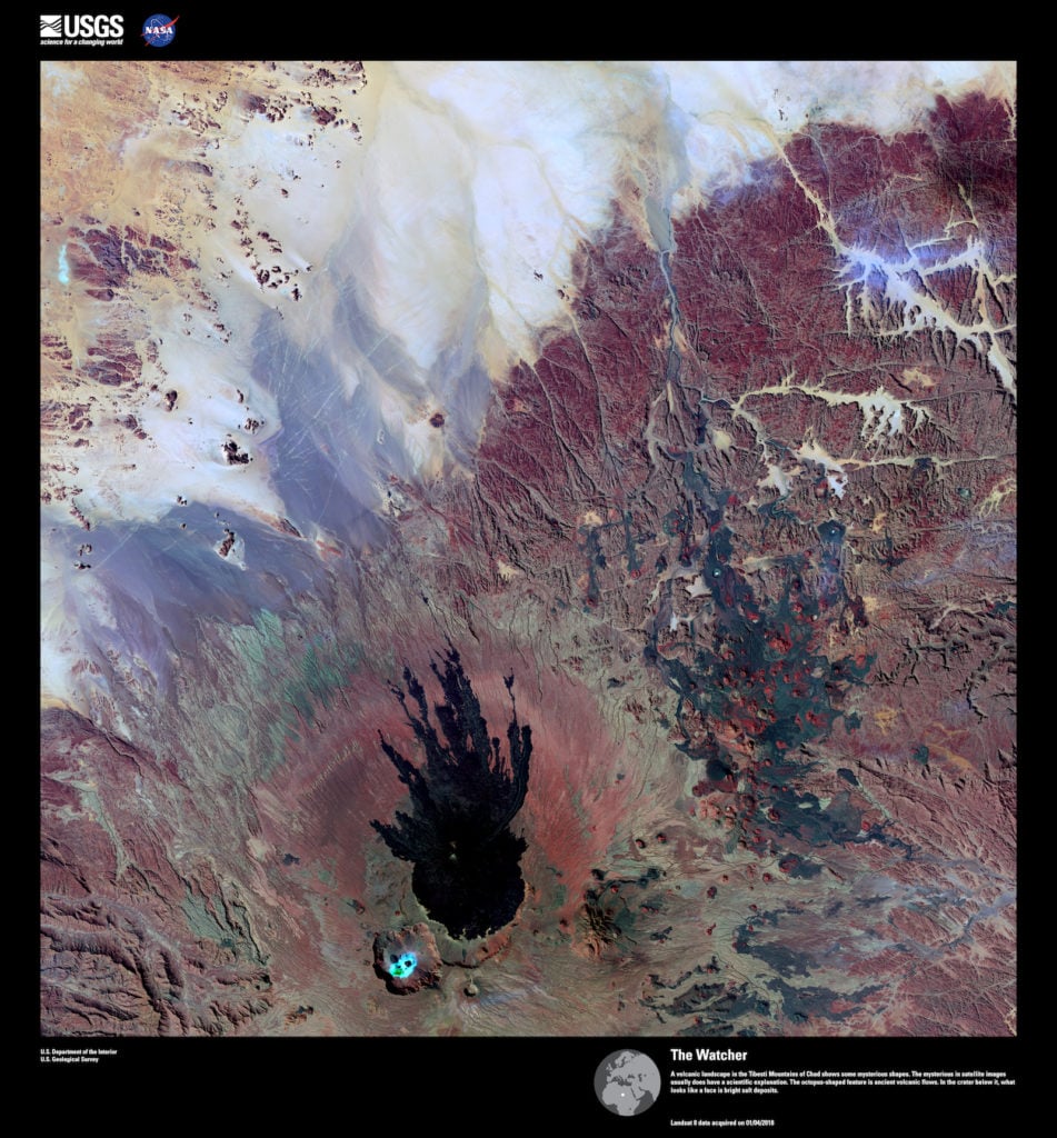
Landsat 8, The Watcher. A volcanic landscape in the Tibesti Mountains of Chad shows some mysterious shapes. However, science can explain mysteries in satellite images. The octopus-shaped feature consists of ancient volcanic flows. In the crater below it, what looks like a face is bright salt deposits. Image courtesy of US Geological Survey/NASA.
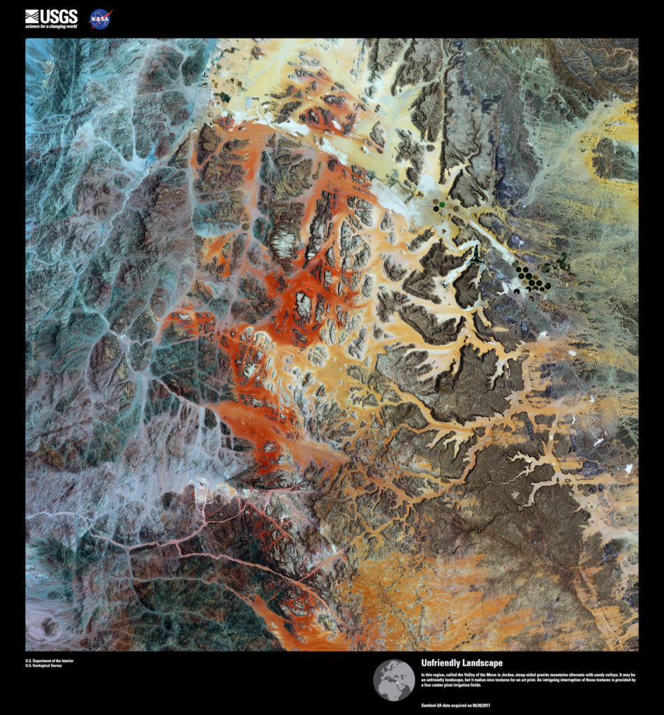
Landsat 8, Unfriendly Landscape. In this region, called the Valley of the Moon in Jordan, steep-sided granite mountains alternate with sandy valleys. It may be an unfriendly landscape, but it makes nice textures for an art print. An intriguing interruption of those textures is provided by a few center pivot irrigation fields. Image courtesy of US Geological Survey/NASA.
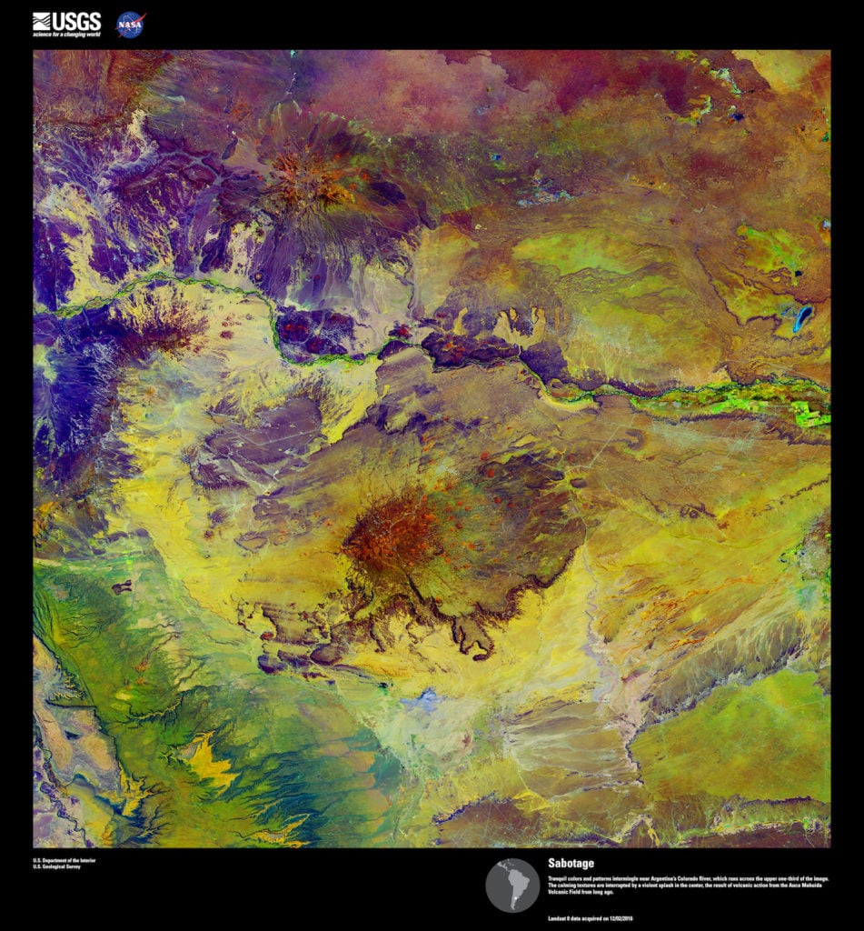
Landsat 8, Sabotage. Tranquil colors and patterns intermingle near Argentina’s Colorado River, which runs across the upper one-third of the image. The calming textures are interrupted by a violent splash in the center, the result of volcanic action from the Auca Mahuida Volcanic Field from long ago. Image courtesy of US Geological Survey/NASA.
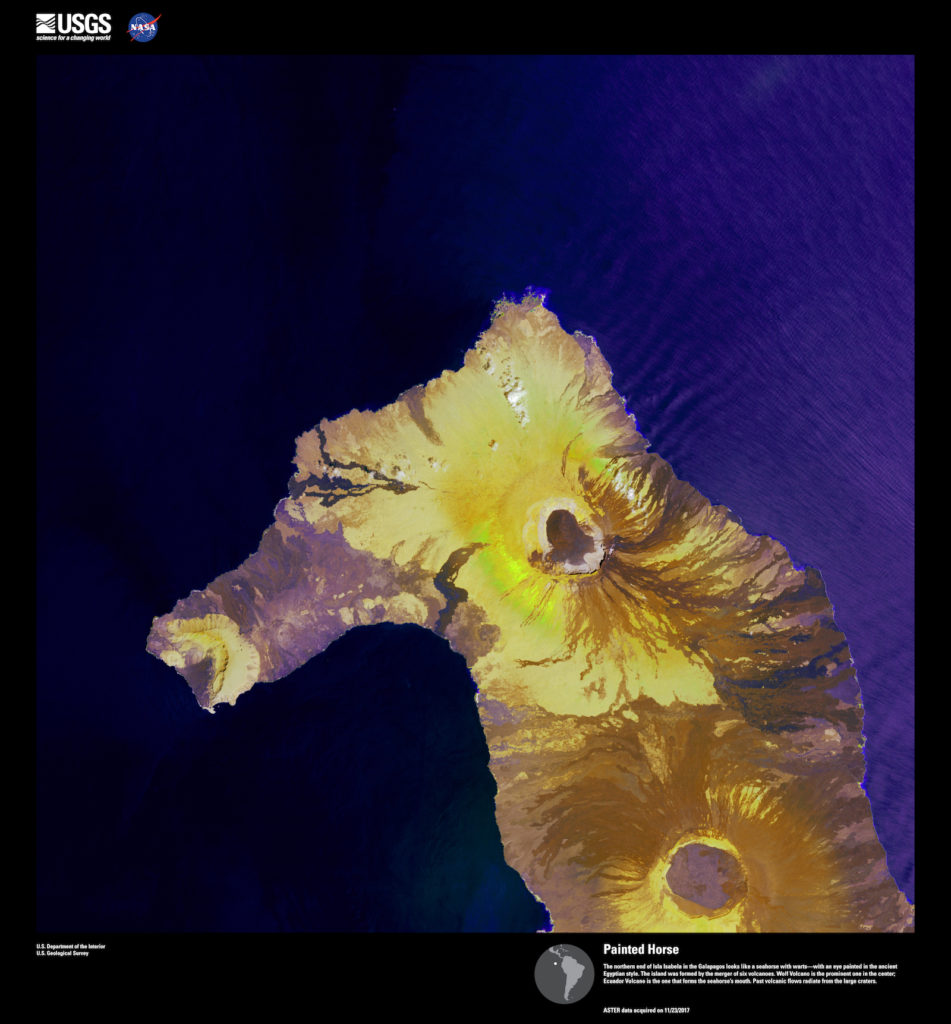
Landsat 8, Painted Horse. The northern end of Isla Isabela in the Galapagos looks like a seahorse with warts—with an eye painted in the ancient Egyptian style. The island was formed by the merger of six volcanoes. Wolf Volcano is the prominent one in the center; Ecuador Volcano is the one that forms the seahorse’s mouth. Past volcanic flows radiate from the large craters. Image courtesy of US Geological Survey/NASA.
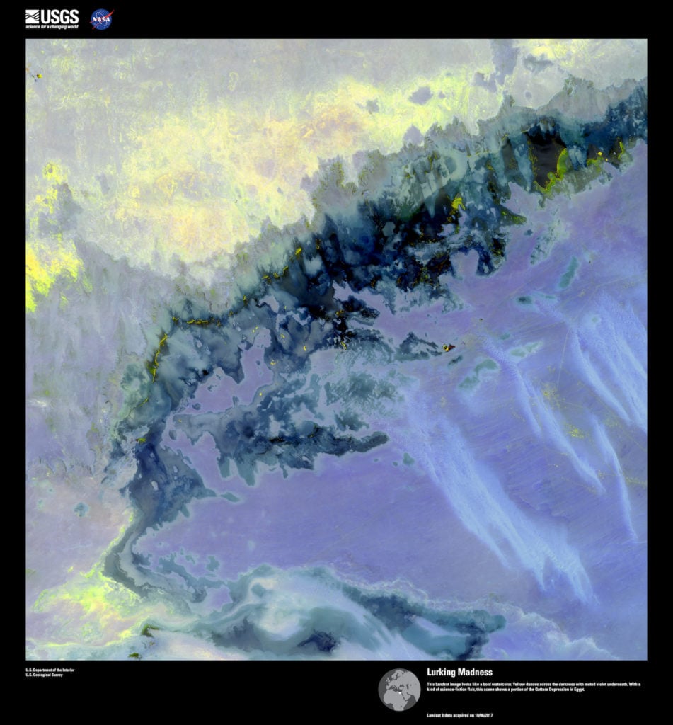
Landsat 8, Lurking Madness. This Landsat image looks like a bold watercolor. Yellow dances across the darkness with muted violet underneath. With a kind of science-fiction flair, this scene shows a portion of the Qattara Depression in Egypt. Image courtesy of US Geological Survey/NASA.
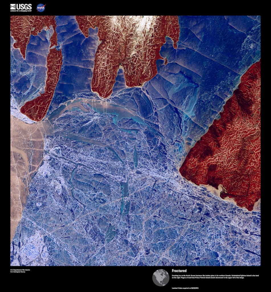
Landsat 8, Fractured. Cracking ice on the Arctic Ocean fractures like broken glass in far northern Canada. Uninhabited Eglinton Island is the land on the right. Fingers of land from Prince Patrick Island stretch downward in the upper left of the image. Image courtesy of US Geological Survey/NASA.
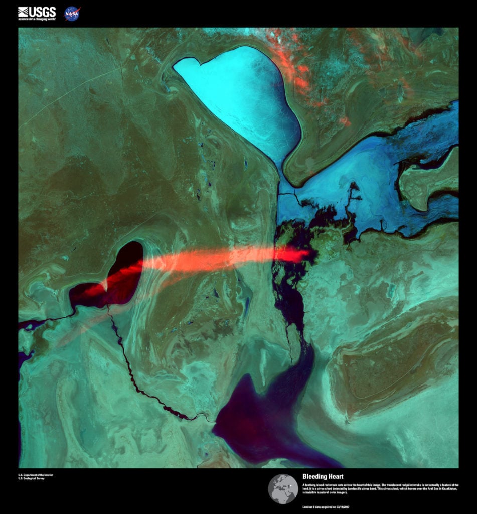
Landsat 8, Bleeding Heart. A feathery, blood red streak cuts across the heart of this image. The translucent red paint stroke is not actually a feature of the land. It is a cirrus cloud detected by Landsat 8’s cirrus band. This cirrus cloud, which hovers over the Aral Sea in Kazakhstan, is invisible in natural color imagery. Image courtesy of US Geological Survey/NASA.
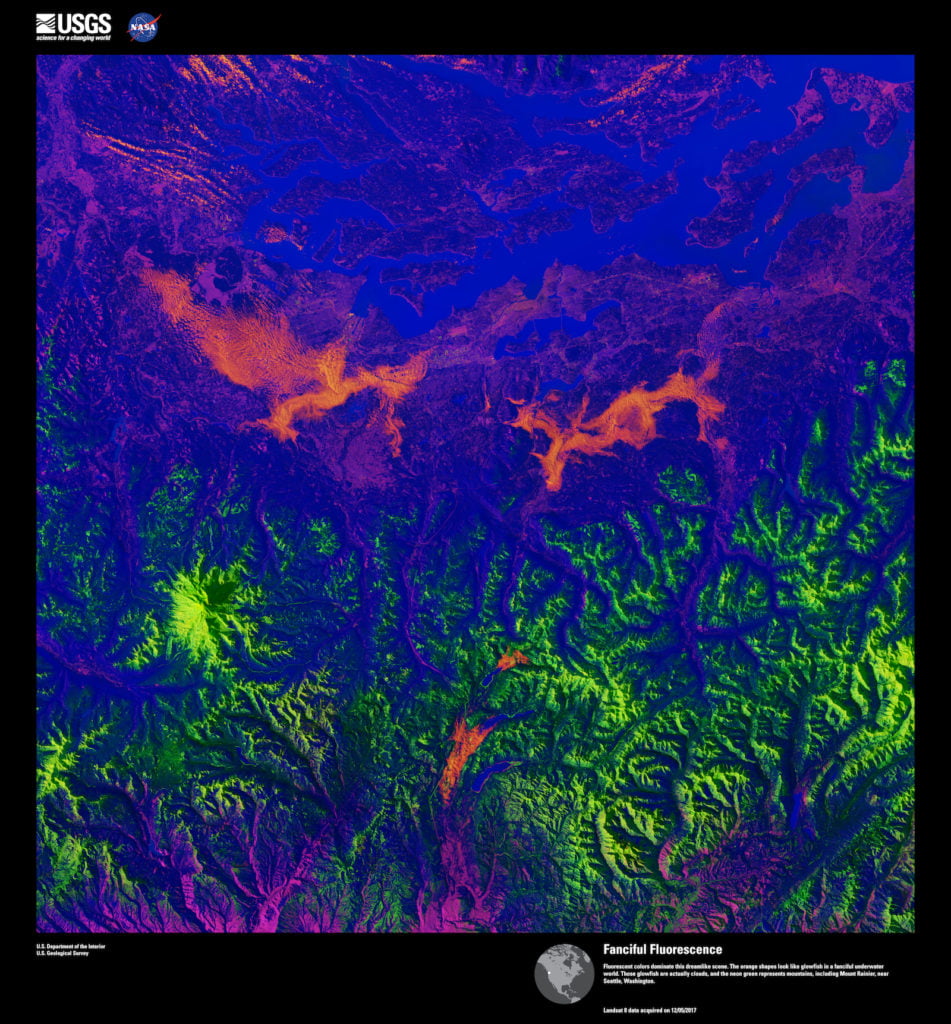
Landsat 8, Fanciful Fluorescence. Fluorescent colors dominate this dreamlike scene. The orange shapes look like glowfish in a fanciful underwater world. Those glowfish are actually clouds, and the neon green represents mountains, including Mount Rainier, near Seattle, Washington. Image courtesy of US Geological Survey/NASA.